IMAGES TAKEN NEAR TO
Church Road, STOCKPORT, SK4 1LJ
Introduction
This page details the photographs taken nearby to Church Road, SK4 1LJ by members of the Geograph project.
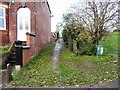
The Geograph project started in 2005 with the aim of publishing, organising and preserving representative images for every square kilometre of Great Britain, Ireland and the Isle of Man.

There are currently over 7.5m images from over14,400 individuals and you can help contribute to the project by visiting https://www.geograph.org.uk
Image Map
Images are licensed for reuse under creativecommons.org/licenses/by-sa/2.0
Notes
- Clicking on the map will re-center to the selected point.
- The higher the marker number, the further away the image location is from the centre of the postcode.
Image Listing (362 Images Found)
Images are licensed for reuse under creativecommons.org/licenses/by-sa/2.0
Image
Details
Distance
1
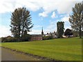
Heaton Norris Recreation Ground
Looking between the trees to Christ Church Image
Image: © Gerald England
Taken: 13 Oct 2012
0.02 miles
2
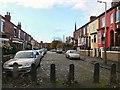
Church Road
The end of Church Road viewed from Heaton Norris Recreation Ground.
Image: © Gerald England
Taken: 20 Nov 2013
0.02 miles
3
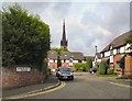
Mulberry Mews
Cuk-de-sac off Parsonage Street with Christ Church spire Image in the background.
Image: © Gerald England
Taken: 10 Sep 2012
0.03 miles
4
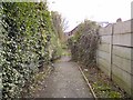
Footpath to Church Road
Leading from Love Lane.
Opposite direction: Image
Image: © Gerald England
Taken: 20 Nov 2013
0.04 miles
5
Footpath to Love Lane
Footpath from the end of Church Road leading to Love Lane.
Image: © Gerald England
Taken: 20 Nov 2013
0.05 miles
6
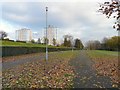
Heaton Norris Recreation Ground
From the end of Church Road looking towards Heaton Towers (left) and Norris Towers (right).
Image: © Gerald England
Taken: 20 Nov 2013
0.05 miles
7
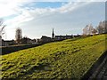
Heaton Norris Recreation Ground
Looking along the bank between the Park and the Recreation Ground with the spire of Christ Church in the background.
Image: © Gerald England
Taken: 30 Nov 2013
0.06 miles
8
Wyatt Street
Looking from Heaton Norris Recreation Ground across towards the Wycliffe Congregational Church Image on Wellington Street North.
Image: © Gerald England
Taken: 13 Oct 2012
0.06 miles
9
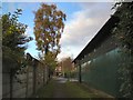
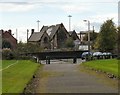
Footpath to Love Lane
Leading from Church Road past the side of Heaton Norris Bowling Club Pavilion.
I'm informed by Robin Stott that the tall tree looks like a hacked-about Silver Birch, Betula pendula. Small leaves, fine shoots, narrow angle of branching (phyllotaxis), droopy, deciduous – leaves turning colour, soon to fall.
Opposite direction: Image
Image: © Gerald England
Taken: 20 Nov 2013
0.07 miles
10
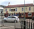
The Railway
Public house on Wellington Road North on the corner of Wyatt Street and opposite George's Road
Image: © Gerald England
Taken: 10 Sep 2012
0.07 miles