IMAGES TAKEN NEAR TO
Thomson Street, STOCKPORT, SK3 9DT
Introduction
This page details the photographs taken nearby to Thomson Street, SK3 9DT by members of the Geograph project.
The Geograph project started in 2005 with the aim of publishing, organising and preserving representative images for every square kilometre of Great Britain, Ireland and the Isle of Man.

There are currently over 7.5m images from over14,400 individuals and you can help contribute to the project by visiting https://www.geograph.org.uk
Image Map
Images are licensed for reuse under creativecommons.org/licenses/by-sa/2.0
Notes
- Clicking on the map will re-center to the selected point.
- The higher the marker number, the further away the image location is from the centre of the postcode.
Image Listing (758 Images Found)
Images are licensed for reuse under creativecommons.org/licenses/by-sa/2.0
Image
Details
Distance
1
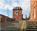
Arden Buildings
Apartment block on Thomson Street Image facing the corner of James Leech Street and Frances Street. On the side is a memorial for Edward VII Image
Image: © Gerald England
Taken: 12 Oct 2015
0.00 miles
2
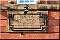
Memorial to Edward VII
The memorial on the Francis Street side Image of Imagereads:
MEMORIAL
TO KING EDWARD VII
ERECTED BY PUBLIC
SUBSCRIPTION
THIS STONE WAS LAID ON NOV 13 1912
BY LT COLONEL ALAN J SKYKES MP DL
Image: © Gerald England
Taken: 12 Oct 2015
0.00 miles
3
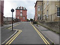
James Leech Street, Stockport
James Leech Street ascends from the A6 Wellington Road South towards Frances Street and Thomson Street. Double yellow lines on both sides indicate no parking at any time.
The southern edge of the Grade II listed former Stockport Infirmary http://www.geograph.org.uk/photo/5112810 is on the right.
Image: © Jaggery
Taken: 10 Sep 2016
0.01 miles
4
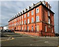
Arden Buildings
On Thomson Street. On the Frances Street end Image facing John Leech Street is a memorial to Edward VII Image
Image: © Gerald England
Taken: 12 Oct 2015
0.01 miles
5
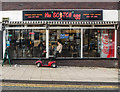
Breakfast at The Scotch Egg, Stockport
Currently rated 267th out of 465 restaurants in the Stockport area.
Image: © Matt Harrop
Taken: 2 Jan 2019
0.03 miles
6
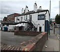
Nelson Tavern, Stockport
The Greek Street side of the pub on the corner of Wellington Road South.
Image: © Jaggery
Taken: 10 Sep 2016
0.03 miles
7
Nelson Tavern
On the corner of Wellington Road South and Greek Street.
Image: © Gerald England
Taken: 2 Oct 2018
0.03 miles
8
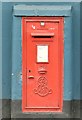
Edward VII postbox (SK1 6)
In the wall of the Nelson Tavern Image
Image: © Gerald England
Taken: 2 Oct 2018
0.03 miles
9
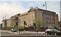
The old Infirmary, Stockport
The building was initially established as a dispensary in 1792, and then incorporated as an infirmary in 1833. The infirmary was expanded four times between 1871 and 1926. The building then remained unchanged until its closure in 1996.
It was listed as Grade II on the Statutory List of Buildings of Special Architectural or Historic Interest on 10 March 1975. The building was purchased by the Brentwood Group and renovated into office space, currently in the use of the UK pension service. It stands on the A6, almost opposite to the Town Hall.
Image: © Tricia Neal
Taken: 10 Apr 2014
0.03 miles
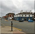
10
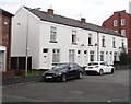
White houses, Thomson Street, Stockport
Viewed from the corner of Blackshaw Street.
Image: © Jaggery
Taken: 10 Sep 2016
0.03 miles