1
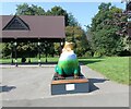
Resilience Frog
Located in Cale Green Park, Resilience Frog represents Davenport and Cale Green Ward. Sponsored by Stephensons it is one of 17 frogs taking up residence in wards across Stockport Borough in addition to the 21 frogs across the town centre. as part of Stockport's Gigantic Leap Frog Art Trail.
Image: © Gerald England
Taken: 7 Sep 2021
0.05 miles
2
South along Heath Road, Cale Green, Stockport
Viewed across the road named Cale Green in the Cale Green area of Stockport.
Image: © Jaggery
Taken: 10 Sep 2016
0.05 miles
3
Northeast corner of Hillcrest Grammar School, Stockport
This is the corner of Heath Road and Beech Avenue. The white banner on display on September 10th 2016
shows that Stockport Lacrosse Club is recruiting boys and girls in the 8-16 age groups.
Image: © Jaggery
Taken: 10 Sep 2016
0.07 miles
4
Junction of Beech Avenue and Cale Green, Stockport
The 20mph speed limit on Beech Avenue on the left increases to 30mph on Cale Green.
Image: © Jaggery
Taken: 10 Sep 2016
0.07 miles
5
Cale Green Conservation Area, Stockport
The Stockport Metropolitan Borough Council website states that Cale Green is an inner residential suburb of Stockport, located one mile from the town centre. Cale Green Park occupies a large part of the Cale Green Conservation Area, which is bounded to the southwest by the Manchester to Buxton railway line, to the east by the historic route of Bramhall Lane, and to the north (this side) by the district of Shaw Heath.
Image: © Jaggery
Taken: 10 Sep 2016
0.08 miles
6
Stockport Cricket Club
Early morning photograph of the bowling green and pitch of Stockport Cricket Club. The memorial column on the left lists the name of club members who lost their lives in the two world wars. The light mist obscures the view of Alderley Edge escarpment in the distance.
Image: © Gethin Evans
Taken: 24 Aug 2007
0.08 miles
7
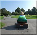
Resilience Frog
Located in Cale Green Park, Resilience Frog represents Davenport and Cale Green Ward. Sponsored by Stephensons it is one of 17 frogs taking up residence in wards across Stockport Borough in addition to the 21 frogs across the town centre. as part of Stockport's Gigantic Leap Frog Art Trail.
Image: © Gerald England
Taken: 7 Sep 2021
0.09 miles
8
Resilience Frog
Located in Cale Green Park, Resilience Frog represents Davenport and Cale Green Ward. Sponsored by Stephensons it is one of 17 frogs taking up residence in wards across Stockport Borough in addition to the 21 frogs across the town centre. as part of Stockport's Gigantic Leap Frog Art Trail.
Image: © Gerald England
Taken: 7 Sep 2021
0.10 miles
9
Cale Green Park
Near the centre of the square
Image: © Chris Shaw
Taken: Unknown
0.11 miles
10
Crocus display at Cale Green
It is not clear whose land this is. It is fenced.
Image: © Bill Boaden
Taken: 12 Mar 2015
0.11 miles


