IMAGES TAKEN NEAR TO
Wellington Road South, STOCKPORT, SK2 6RS
Introduction
This page details the photographs taken nearby to Wellington Road South, SK2 6RS by members of the Geograph project.
The Geograph project started in 2005 with the aim of publishing, organising and preserving representative images for every square kilometre of Great Britain, Ireland and the Isle of Man.

There are currently over 7.5m images from over14,400 individuals and you can help contribute to the project by visiting https://www.geograph.org.uk
Image Map (Loading...)


Getting Data...Please wait
Leaflet Map data © OpenStreetMap
Images are licensed for reuse under creativecommons.org/licenses/by-sa/2.0
Notes
- Clicking on the map will re-center to the selected point.
- The higher the marker number, the further away the image location is from the centre of the postcode.
Image Listing (195 Images Found)
Images are licensed for reuse under creativecommons.org/licenses/by-sa/2.0
Image
Details
Distance
1
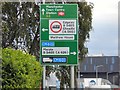
Signage on Wellington Road South
The sign here Image directs traffic for Edgeley and Cheadle left on the B5465 and traffic for Marple and the M60 right. New mapping appears to show that Longshut Lane on the left will become unclassified whilst the road to the right will be renumbered as the A6188 together with the rest of the A626 along St Mary's Way and Tiviot Way and on to Heaton Norris.
Image: © Gerald England
Taken: 10 Jun 2019
0.02 miles
2
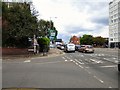
Wellington Road South
The A6 into Stockport. Ahead is the junction with the current B5465. New mapping appears to show that this part of the B5465 is being renumbered as the A6188 together the rest of the A626 along St Mary's Way and Tiviot Way and on to Heaton Norris. It may be some time before the re-numbering appears on signage Image
Image: © Gerald England
Taken: 10 Jun 2019
0.02 miles
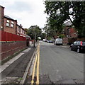
3
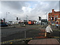
Longshut Lane and Wellington Road (A6)
Honda car showrooms, traffic lights and a lady gambling on getting across when the lights show red for pedestrians.
Image: © Peter Barr
Taken: 15 Feb 2013
0.02 miles
4
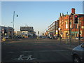
Junction Wellington Road South and Longshut Lane
Looking north with the square modern buildings of Stockport College on the left.
Image: © Peter Turner
Taken: 15 Nov 2011
0.03 miles
5
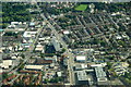
Wellington Road South, Stockport, from the air
Image: © Mike Pennington
Taken: 24 Aug 2018
0.03 miles
6
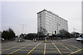
St Christopher House
A free-standing office block by the A6.
Image: © Bill Boaden
Taken: 12 Mar 2015
0.04 miles
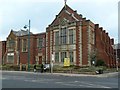
7
Stockport Health Centre
At the corner of Wellington Road South and Lowfield Road.
Image: © Gerald England
Taken: 29 Apr 2010
0.04 miles
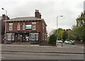
9
Lyme Grove, Shaw Heath, Stockport
On the east side of the road named Shaw Heath in the Shaw Heath area of Stockport.
Image: © Jaggery
Taken: 10 Sep 2016
0.08 miles
10
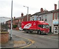
Longshut Lane West
The B5465 between Shaw Heath and Wellington Road South. The red lorry belonging to AAH pharmaceuticals was delivering to Lloyds Pharmacy Image
Image: © Gerald England
Taken: 24 Feb 2014
0.09 miles