IMAGES TAKEN NEAR TO
Bridgemont, HIGH PEAK, SK23 7PB
Introduction
This page details the photographs taken nearby to Bridgemont, SK23 7PB by members of the Geograph project.
The Geograph project started in 2005 with the aim of publishing, organising and preserving representative images for every square kilometre of Great Britain, Ireland and the Isle of Man.

There are currently over 7.5m images from over14,400 individuals and you can help contribute to the project by visiting https://www.geograph.org.uk
Image Map (Loading...)


Getting Data...Please wait
Leaflet Map data © OpenStreetMap
Images are licensed for reuse under creativecommons.org/licenses/by-sa/2.0
Notes
- Clicking on the map will re-center to the selected point.
- The higher the marker number, the further away the image location is from the centre of the postcode.
Image Listing (78 Images Found)
Images are licensed for reuse under creativecommons.org/licenses/by-sa/2.0
Image
Details
Distance
1
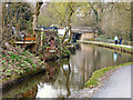
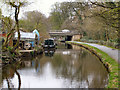
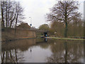
Peak Forest Canal
Behind the Old Buxton Road
Image: © David Dixon
Taken: 18 Apr 2010
0.03 miles
2
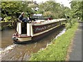
Passenger carrying narrowboat, Judith Mary II, on Peak Forest Canal
Pride of the Peak - a floating restaurant
Image: © Chris Morgan
Taken: 10 Sep 2012
0.03 miles
3
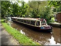
Afternoon tea on the canal
The passing barge 'Judith Mary II' is on a canal cruise from its base at Whaley Bridge and all the passengers were enjoying sandwiches, tea and cakes at the time.
Image: © Graham Hogg
Taken: 10 Sep 2012
0.03 miles
4
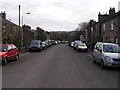
Bridgemont
Formerly the main route from Whaley Bridge to Marple, now bypassed by the A6.
Image: © Dave Dunford
Taken: 18 Dec 2005
0.03 miles
5
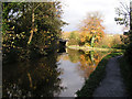
Peak Forest Canal
The section between Buxton Road (A5004) and the A6
Image: © David Dixon
Taken: 18 Apr 2010
0.04 miles
6
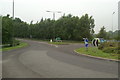
Roundabout at the start of the Whaley Bridge A6 by-pass
Image: © David Long
Taken: 22 Jun 2009
0.05 miles
7
Peak Forest Canal
Looking northwards to the A5004 bridge over the canal. The branch to the right leads eastwards to Buxworth Basin (which has recently been reopened to boats after major leakage problems had scuppered an earlier restoration).
Image: © Dave Dunford
Taken: 12 Nov 2005
0.05 miles
8
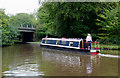
Peak Forest Canal north of Whaley Bridge, Derbyshire
Narrowboat "Rhapsody" (in blue!!) has just emerged from the canal arm which leads to Bugsworth Basin. The bridge carries the A5004 Buxton Road.
Image: © Roger D Kidd
Taken: 6 Sep 2014
0.06 miles
9
Peak Forest Canal: Whaley Bridge Basin
Looking across the Whaley Bridge Basin towards the Buxton Road Bridge.
Image: © David Dixon
Taken: 18 Apr 2010
0.07 miles
10
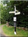
Canal signpost on the Peak Forest Canal
The canal forks here with arms from Whaley Bridge and Bugsworth Basin joining to form the main route to Marple
Image: © Graham Hogg
Taken: 10 Sep 2012
0.07 miles