IMAGES TAKEN NEAR TO
Craig Drive, HIGH PEAK, SK23 7LD
Introduction
This page details the photographs taken nearby to Craig Drive, SK23 7LD by members of the Geograph project.
The Geograph project started in 2005 with the aim of publishing, organising and preserving representative images for every square kilometre of Great Britain, Ireland and the Isle of Man.

There are currently over 7.5m images from over14,400 individuals and you can help contribute to the project by visiting https://www.geograph.org.uk
Image Map
Images are licensed for reuse under creativecommons.org/licenses/by-sa/2.0
Notes
- Clicking on the map will re-center to the selected point.
- The higher the marker number, the further away the image location is from the centre of the postcode.
Image Listing (34 Images Found)
Images are licensed for reuse under creativecommons.org/licenses/by-sa/2.0
Image
Details
Distance
1
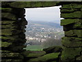
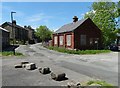
View through hole in wall from Long Lane towards Horwich End
Image: © Colin Park
Taken: 6 Mar 2014
0.05 miles
2
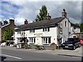
The Drum & Monkey
The brewery tap for the nearby Whaley Bridge Brewery
Image: © Graham Hogg
Taken: 15 Sep 2017
0.09 miles
3
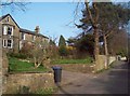
Eccles Road in Over Leigh
The dwelling to the left of picture is Park House West.
Image: © Jonathan Clitheroe
Taken: 24 Mar 2012
0.12 miles
4
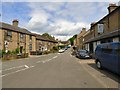
Old Road
From Horwich End via New Horwich to Whaley Bridge.
Image: © Gerald England
Taken: 1 Jun 2017
0.13 miles
5
Old railway building in Horwich End
Now disused, close to the course of a long redundant track.
Image: © Neil Theasby
Taken: 4 Jun 2015
0.13 miles
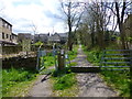
6
Trackbed of the Cromford and High Peak Railway
The B5470 passes over the line near Whaley Bridge
Image: © Raymond Knapman
Taken: 30 Mar 2016
0.14 miles
7
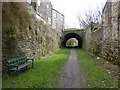
The foot of the Shallcross Incline
Recently turned into a public path
Image: © Raymond Knapman
Taken: 26 Apr 2018
0.14 miles
8
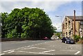
Horwich End
The road approaching the crossroads at Horwich End from Chapel-en-le-Frith is now the B5470 that crosses the A5004 and continues to Macclesfield. The A5004 was originally the A6 from Buxton to Whaley Bridge via Long Hill and this road was then the end of the A625. In the 1960s the A6 re-routed through Chapel to Horwich End and the road over Long Hill was renumbered A5004. When Chapel-en-le-Frith was bypassed in the 1980s it carried the A6 and this road became the B5470.
Image: © Gerald England
Taken: 1 Jun 2017
0.15 miles
9
Narrow gauge railway at New Road
This small scale internal industrial railway was spotted at Whaley Bridge
Image: © Raymond Knapman
Taken: 30 Mar 2016
0.15 miles
10
The foot of the Shallcross Incline
Now used as a recreation pathway this was an incline on the Cromford and High Peak Railway and worked by stationary engines first by chain then by wire rope.
Image: © Raymond Knapman
Taken: 30 Mar 2016
0.15 miles