IMAGES TAKEN NEAR TO
New Mills Road, HIGH PEAK, SK22 2JG
Introduction
This page details the photographs taken nearby to New Mills Road, SK22 2JG by members of the Geograph project.
The Geograph project started in 2005 with the aim of publishing, organising and preserving representative images for every square kilometre of Great Britain, Ireland and the Isle of Man.

There are currently over 7.5m images from over14,400 individuals and you can help contribute to the project by visiting https://www.geograph.org.uk
Image Map
Images are licensed for reuse under creativecommons.org/licenses/by-sa/2.0
Notes
- Clicking on the map will re-center to the selected point.
- The higher the marker number, the further away the image location is from the centre of the postcode.
Image Listing (151 Images Found)
Images are licensed for reuse under creativecommons.org/licenses/by-sa/2.0
Image
Details
Distance
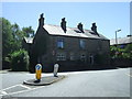
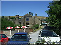
1
The Kinder Lodge, Hayfield
Decorated for the football world cup, 2018.
On New Mills Road.
Image: © JThomas
Taken: 30 Jun 2018
0.01 miles
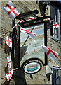
3
Kinder Lodge
Hotel and public house in the centre of Hayfield.
Image: © Gerald England
Taken: 20 May 2011
0.02 miles
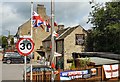
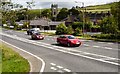
5

A624, Hayfield
Junction with the A6015 - looking south east.
Image: © JThomas
Taken: 30 Jun 2018
0.04 miles
6
The George Hotel, Hayfield
View from the A624.
Image: © JThomas
Taken: 30 Jun 2018
0.05 miles
7
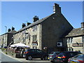
Hayfield Village
The A624 through Hayfield from the junction with the A6015 from New Mills.
Image: © Gerald England
Taken: 20 May 2011
0.05 miles
8
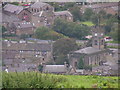
Hayfield village centre from the northeast
Looking WSW from approx. SK041871 (near Twenty Trees - see Image), showing the parish church of St. Matthew prominently to the right of centre, the Bull Inn just left of centre (with the black-painted window surrounds) and St. John's Methodist church (top left). The site of the former railway station and sidings (now a car park and visitor centre) is to the right beyond the main road, behind the church in this picture.
Image: © Dave Dunford
Taken: 11 Sep 2004
0.05 miles
9
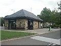
Visitor Information Centre, Hayfield
At one end of the Sett Valley Trail.
Image: © Katy Walters
Taken: 10 Aug 2006
0.05 miles
10
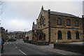
St John's Methodist Church
This was a Wesleyan chapel erected in 1782.
Image: © Bill Boaden
Taken: 5 Mar 2011
0.06 miles