IMAGES TAKEN NEAR TO
Macclesfield Road, BUXTON, SK17 9AG
Introduction
This page details the photographs taken nearby to Macclesfield Road, SK17 9AG by members of the Geograph project.
The Geograph project started in 2005 with the aim of publishing, organising and preserving representative images for every square kilometre of Great Britain, Ireland and the Isle of Man.

There are currently over 7.5m images from over14,400 individuals and you can help contribute to the project by visiting https://www.geograph.org.uk
Image Map
Images are licensed for reuse under creativecommons.org/licenses/by-sa/2.0
Notes
- Clicking on the map will re-center to the selected point.
- The higher the marker number, the further away the image location is from the centre of the postcode.
Image Listing (31 Images Found)
Images are licensed for reuse under creativecommons.org/licenses/by-sa/2.0
Image
Details
Distance
2
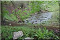
Wye Head
One of the main sources of the River Wye, this resurgence is next to a footpath and just below the B5059 (this picture is taken from the pavement). The water disappears from sight in Poole's Cavern and flows to this point through passages impenetrable to cavers.
Image: © Dave Dunford
Taken: 7 May 2012
0.10 miles
3
Wye Head
One of the main sources of the River Wye, this resurgence is next to a footpath and just below the B5059 (a bus shelter can be seen through the trees above the spring). The water disappears from sight in Poole's Cavern and flows to this point through passages impenetrable to cavers.
Image: © Dave Dunford
Taken: 7 May 2012
0.10 miles
4
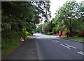
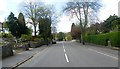
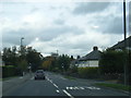
St. John's Road in Buxton
The A53 road seen here heading out of town towards Burbage.
Image: © Jonathan Clitheroe
Taken: 25 Jun 2012
0.11 miles
5
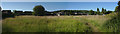
Behind the houses
An open field with a footpath along the left-hand edge
Image: © Bob Harvey
Taken: 29 Jun 2018
0.11 miles
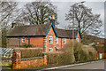
7
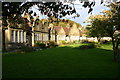
Cottages Macclesfield Road
A group of 12 Grade II Listed almshouses of 1904. Architect was W.R. Bryden who designed them for Sir James Sawyer. The plans were published in The Building News on January 27th 1905.
Image: © Jo and Steve Turner
Taken: 9 Oct 2004
0.15 miles
8
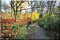
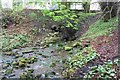
Downstream From Gadley Lane
This is the stream which runs, eventually, beneath Buxton Centre.
Image: © Bob Jenkins
Taken: 2 Nov 2009
0.17 miles
9
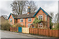
112 & 114 Macclesfield Road
Pair of semi-detached houses on Macclesfield Road, shown on the 1878 25" map.
Image: © Ian Capper
Taken: 12 Mar 2024
0.20 miles
10
112 & 114 Macclesfield Road
Pair of semi-detached houses on Macclesfield Road, shown on the 1878 25" map.
Image: © Ian Capper
Taken: 12 Mar 2024
0.20 miles