IMAGES TAKEN NEAR TO
Litton Dale, BUXTON, SK17 8RY
Introduction
This page details the photographs taken nearby to Litton Dale, SK17 8RY by members of the Geograph project.
The Geograph project started in 2005 with the aim of publishing, organising and preserving representative images for every square kilometre of Great Britain, Ireland and the Isle of Man.

There are currently over 7.5m images from over14,400 individuals and you can help contribute to the project by visiting https://www.geograph.org.uk
Image Map
Images are licensed for reuse under creativecommons.org/licenses/by-sa/2.0
Notes
- Clicking on the map will re-center to the selected point.
- The higher the marker number, the further away the image location is from the centre of the postcode.
Image Listing (69 Images Found)
Images are licensed for reuse under creativecommons.org/licenses/by-sa/2.0
Image
Details
Distance
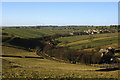
3
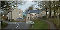
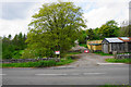
Construction in Litton Dale
Tideswell can be seen on horizon
Image: © Peter Barr
Taken: 21 Jun 2009
0.07 miles
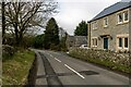
4
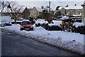
Approaching Litton from Tideswell Dale
The road climbs steadily to the village, with a pavement for walkers above a grassy bank.
Image: © Andrew Hill
Taken: 8 Mar 2012
0.08 miles
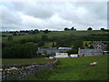
8
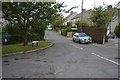
Litton Logs
A source of firewood in Litton Dale.
Image: © Bill Boaden
Taken: 20 May 2016
0.13 miles
9
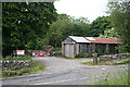
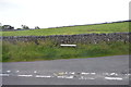
Litton Logs
These are the premises of a supplier of logs, no doubt for firewood.
Image: © Anne Burgess
Taken: 25 Jun 2014
0.13 miles