IMAGES TAKEN NEAR TO
Buxton Road, BUXTON, SK17 8QJ
Introduction
This page details the photographs taken nearby to Buxton Road, SK17 8QJ by members of the Geograph project.
The Geograph project started in 2005 with the aim of publishing, organising and preserving representative images for every square kilometre of Great Britain, Ireland and the Isle of Man.

There are currently over 7.5m images from over14,400 individuals and you can help contribute to the project by visiting https://www.geograph.org.uk
Image Map
Images are licensed for reuse under creativecommons.org/licenses/by-sa/2.0
Notes
- Clicking on the map will re-center to the selected point.
- The higher the marker number, the further away the image location is from the centre of the postcode.
Image Listing (24 Images Found)
Images are licensed for reuse under creativecommons.org/licenses/by-sa/2.0
Image
Details
Distance
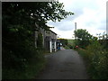
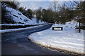
2
Tideswell, looking back towards Town End
Image: © Peter Barr
Taken: 21 Jun 2009
0.07 miles
5
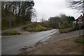
Diverging roads at the south end of Tideswell
The centre road is the main one, which continues down Tideswell Dale to Miller's Dale.
Image: © Bill Boaden
Taken: 10 Mar 2012
0.10 miles
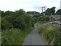
6
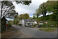
The B6049 entering Town End, Tideswell
'The Clock House' ahead
Image: © Tim Heaton
Taken: 4 Nov 2021
0.13 miles
8
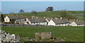
View to Tideswell from Meadow Lane
The southern edge of the village, Town End, surrounded by green fields.
Image: © Andrew Hill
Taken: 21 Mar 2012
0.14 miles
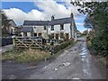
9
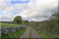
Farm track to Tideswell
Running along the lip of the dale, above the B6049
Image: © Tim Heaton
Taken: 4 Nov 2021
0.15 miles
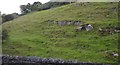
10
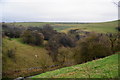
The beginning of Tideswell Dale
Just south of the village of Tideswell. Litton Dale arrives from the left, and Tideswell Dale continues down to the right.
Image: © Bill Boaden
Taken: 10 Mar 2012
0.16 miles