IMAGES TAKEN NEAR TO
Manchester Road, BUXTON, SK17 8LN
Introduction
This page details the photographs taken nearby to Manchester Road, SK17 8LN by members of the Geograph project.
The Geograph project started in 2005 with the aim of publishing, organising and preserving representative images for every square kilometre of Great Britain, Ireland and the Isle of Man.

There are currently over 7.5m images from over14,400 individuals and you can help contribute to the project by visiting https://www.geograph.org.uk
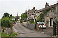
Image Map
Images are licensed for reuse under creativecommons.org/licenses/by-sa/2.0
Notes
- Clicking on the map will re-center to the selected point.
- The higher the marker number, the further away the image location is from the centre of the postcode.
Image Listing (15 Images Found)
Images are licensed for reuse under creativecommons.org/licenses/by-sa/2.0
Image
Details
Distance
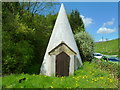
1

Covered Well
Well with a strange conical roof. The roof has recently been repaired with new rendering.
Image: © Tony Bacon
Taken: 10 May 2018
0.02 miles
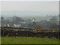
2
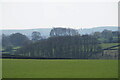
Trees near Tideswell
Looking down from the A623.
Image: © Bill Boaden
Taken: 16 Apr 2022
0.03 miles
3
Conical Well
Front view of pictureImage showing heavy wooden door.
Image: © Tony Bacon
Taken: 10 May 2018
0.03 miles
4
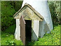
Disused Well
Closer picture of Image with the heavy wooden door open.
Image: © Tony Bacon
Taken: 10 May 2018
0.03 miles
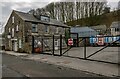
6
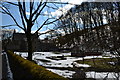
House with greenhouse, Manchester Road, Tideswell
Snow is still covering much of the land.
Image: © Peter Barr
Taken: 3 Apr 2013
0.12 miles
7
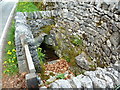
Old Well
A well which was the village's main source of water until mains water was installed.
Image: © Tony Bacon
Taken: 10 May 2018
0.12 miles
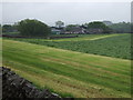
8
Townhead, Tideswell on a misty January day
Image: © Peter Barr
Taken: 25 Jan 2010
0.14 miles
10
Bank View
Tideswell is full of steep narrow streets like this one.
Image: © Anne Burgess
Taken: 25 Jun 2014
0.19 miles