IMAGES TAKEN NEAR TO
Earl Sterndale, BUXTON, SK17 0DE
Introduction
This page details the photographs taken nearby to SK17 0DE by members of the Geograph project.
The Geograph project started in 2005 with the aim of publishing, organising and preserving representative images for every square kilometre of Great Britain, Ireland and the Isle of Man.

There are currently over 7.5m images from over14,400 individuals and you can help contribute to the project by visiting https://www.geograph.org.uk
Image Map
Images are licensed for reuse under creativecommons.org/licenses/by-sa/2.0
Notes
- Clicking on the map will re-center to the selected point.
- The higher the marker number, the further away the image location is from the centre of the postcode.
Image Listing (5 Images Found)
Images are licensed for reuse under creativecommons.org/licenses/by-sa/2.0
Image
Details
Distance
1
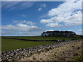
Shelter belt at Cronkston Lodge
The copse has been planted to the north east side of the house.
Image: © Peter Barr
Taken: 27 Mar 2010
0.02 miles
2
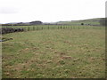
Across the fields from Needham Grange
Limestone country with rough upland pasture - most of which is enclosed for sheep.
Image: © Roger Temple
Taken: 13 Jan 2007
0.11 miles
3
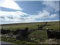
Waggon Low
Gate, tumbledown walls and dewpond.
Image: © Peter Barr
Taken: 27 Mar 2010
0.16 miles
4
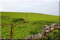
Fields near Cronkston Lodge
These fields are all rough pasture and in many places the bedrock penetrates through the soil to the surface.This is the northern slope of the hill known as Wagon Low
Image: © Nigel Mykura
Taken: 10 Jun 2017
0.17 miles
5
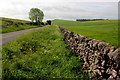
The road to Custard Field Farm
This lane bordered with dry stone walls, runs from Cronkston Lodge to the farm. The prominent hill is Mosey Low and the trees to the right of it are at Pilsbury Lodge in SK1164.
Image: © Nigel Mykura
Taken: 10 Jun 2017
0.24 miles