IMAGES TAKEN NEAR TO
Peel Street, DUKINFIELD, SK16 4XJ
Introduction
This page details the photographs taken nearby to Peel Street, SK16 4XJ by members of the Geograph project.
The Geograph project started in 2005 with the aim of publishing, organising and preserving representative images for every square kilometre of Great Britain, Ireland and the Isle of Man.

There are currently over 7.5m images from over14,400 individuals and you can help contribute to the project by visiting https://www.geograph.org.uk
Image Map
Images are licensed for reuse under creativecommons.org/licenses/by-sa/2.0
Notes
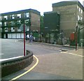
- Clicking on the map will re-center to the selected point.
- The higher the marker number, the further away the image location is from the centre of the postcode.
Image Listing (153 Images Found)
Images are licensed for reuse under creativecommons.org/licenses/by-sa/2.0
Image
Details
Distance
2
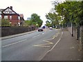
Crescent Road
The B6170 through Dukinfield.
Image: © Gerald England
Taken: 20 May 2010
0.06 miles
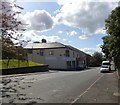
3
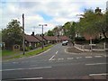
Crescent Close
A cul-de-sac off Crescent Road, Dukinfield.
Image: © Gerald England
Taken: 20 May 2010
0.06 miles
4
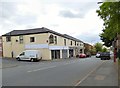
Astley Street
The former Hydes pub the Newborough Inn Image at 31 Astley Street is now the Raja Bros Extra convenience store. For now it still carries the old inn sign Image
Image: © Gerald England
Taken: 31 May 2016
0.06 miles
5
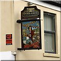
Sign of the Newborough Inn
Although the former Hydes pub the Newborough Inn Image at 31 Astley Street is now the Raja Bros Extra convenience store Image, it still carries the old inn sign for now.
Image: © Gerald England
Taken: 31 May 2016
0.06 miles
6
Astley Street
Part of the B6169 https://www.sabre-roads.org.uk/wiki/index.php?title=B6169 through Dukinfield.
One part of the former Hydes pub the Newborough Inn Image at 31 Astley Street is now the Raja Bros Extra convenience store. Another part, which still carries the old pub sign Image, is being converted into an Indian Restaurant called The Pepper Front.
Image: © Gerald England
Taken: 8 Sep 2017
0.07 miles
7
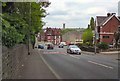
Crescent Road
The B6170 through Dukinfield.
Image: © Gerald England
Taken: 20 May 2010
0.07 miles
8
Dukinfield Methodist Church
The first Methodist Church in Dukinfield opened in 1829. It was replaced by a large building called "Bethesda" which opened in 1840. In 1860 a large gallery was added to the chapel taking the seating capacity to over 1000, making it the largest chapel in the Ashton circuit. In 1898 the original Sunday school building was replaced by a new building, which remains in use today. In 1969 the Primitive Methodist Church in Foundry Street closed and the two congregations amalgamated. The last service of the old chapel was held on 20th May 1977, and the foundation stone of the new chapel laid on 11th December 1977 with the new building opening on September 9th 1978. http://web.archive.org/web/20130808235003/http://www.dukinfieldmethodist.org.uk/History/History.html
Image: © Gerald England
Taken: 13 Mar 2013
0.07 miles
9
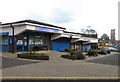
Wellington Parade
At one end are offices of housing group New Charter. Previously known as the "Central Neighbourhood Centre", it is now called "Dukinfield Home and Community Hub". At the other end are the offices of the former Tameside Blind Association (established 1975) but known since 2011 as "Tameside Sight". http://web.archive.org/web/20130507080108/http://www.tamesidesight.org.uk/ In the background is St Mark's Church Image
Image: © Gerald England
Taken: 13 Mar 2013
0.07 miles
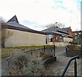
10
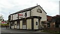
Newborough Inn
On the corner of Astley Street and Zetland Street.
Image
Image: © Gerald England
Taken: 20 May 2010
0.08 miles