IMAGES TAKEN NEAR TO
Chapel Hill, DUKINFIELD, SK16 4BT

Introduction

This page details the photographs taken nearby to Chapel Hill, SK16 4BT by members of the Geograph project.

The Geograph project started in 2005 with the aim of publishing, organising and preserving representative images for every square kilometre of Great Britain, Ireland and the Isle of Man.

There are currently over 7.5m images from over14,400 individuals and you can help contribute to the project by visiting https://www.geograph.org.uk

Image Map


Images are licensed for reuse under creativecommons.org/licenses/by-sa/2.0
Notes
  • Clicking on the map will re-center to the selected point.
  • The higher the marker number, the further away the image location is from the centre of the postcode.

Image Listing (174 Images Found)

Images are licensed for reuse under creativecommons.org/licenses/by-sa/2.0
  • ...
Image
Details
Distance
1
The corner of Chapel Street and Crescent Road
On the left is the Grade II Listed https://historicengland.org.uk/listing/the-list/list-entry/1068073 war memorial on Chapel Hill Image Crescent Road on the right is the B6170. It would appear that some errant motorist has knocked over the bollard on the corner.
Image: © Gerald England Taken: 27 Mar 2018
0.01 miles
2
Top Astley
The Robinson's pub, The Astley Arms, on the corner of Old Road and Crescent Road is known as Top Astley to distinguish it from the Astley Arms Image on Astley Road. The benches in the foreground overlook the war memorial Image
Image: © Gerald England Taken: 31 May 2016
0.02 miles
3
War memorial in Dukinfield
Dukinfield doesn't appear to have a centre, but has a bit of focus here on Crescent Road and another bit down on King Street. The war memorial must be on the highest point of Dukinfield.
Image: © Bill Boaden Taken: 10 Feb 2014
0.02 miles
4
Boat House Day Nursery
The day nursery on Town Lane, Dukinfield is one of six owned by Carole Melia. The others are in Mossley, Ashton-under-Lyne, Radcliffe, Hyde and Droylsden. Website: http://www.boathousedaynursery.co.uk/
Image: © Gerald England Taken: 31 May 2016
0.02 miles
5
Astley Arms
The Astley Arms, on Chapel Hill, Dukinfield. Image] is behind the pub, to the left hand side of the photograph.
Image: © David Dixon Taken: 4 Jun 2011
0.02 miles
6
Astley Arms (Top Astley), Old Road - Dukinfield
With Old Chapel Church to the left. The pub is known locally as Top Astley.
Image: © John Topping Taken: 16 Dec 2012
0.02 miles
7
Astley Arms
The Astley Arms public house in Dukinfield.
Image: © Peter McDermott Taken: 2 Jan 2015
0.02 miles
8
Andrew Moynihan VC
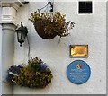
On the wall of the Astley Arms Image are two plaques. The blue plaque reads: TAMESIDE METROPOLITAN BOROUGH Andrew Moynihan VC 1831-1867 Awarded the Victoria Cross for gallantry in the Crimean War. Honoured here on his return to Dukinfield in 1856 Unveiled by Councillor John Taylor March 1996 A second plaque above it reads: To commemorate 150 years of Andrew Moynihan being awarded the Victoria Cross in September 1855. This plaque was unveiled on the 14th September 2005 by Lord Colin Moynihan
Image: © Gerald England Taken: 8 Sep 2017
0.02 miles
9
Hill Crest
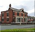
Large house at the top of Chapel Street on the corner of Russel Street.
Image: © Gerald England Taken: 31 May 2016
0.02 miles
10
Dukinfield War Memorial
This memorial, at Chapel Street, commemorates the residents of Dukinfield who were killed or missing in World War I (460 names) and World War II (81 names). For a list of names, see http://www.carlscam.com/dukinfield/memorial.htm
Image: © David Dixon Taken: 4 Jun 2011
0.03 miles
  • ...