IMAGES TAKEN NEAR TO
Castle Cottages, STALYBRIDGE, SK15 3QE
Introduction
This page details the photographs taken nearby to Castle Cottages, SK15 3QE by members of the Geograph project.
The Geograph project started in 2005 with the aim of publishing, organising and preserving representative images for every square kilometre of Great Britain, Ireland and the Isle of Man.

There are currently over 7.5m images from over14,400 individuals and you can help contribute to the project by visiting https://www.geograph.org.uk
Image Map
Images are licensed for reuse under creativecommons.org/licenses/by-sa/2.0
Notes
- Clicking on the map will re-center to the selected point.
- The higher the marker number, the further away the image location is from the centre of the postcode.
Image Listing (37 Images Found)
Images are licensed for reuse under creativecommons.org/licenses/by-sa/2.0
Image
Details
Distance
1
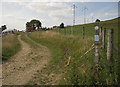
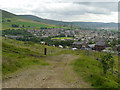
Pennine Bridleway near Castle Farm
Castle Farm is on Castle Lane just out of shot on the left. The track is Moor Edge Road that forms part of the National Trail between Carrbrook and Greenfield. Here we are looking towards Greenfield.
Image: © michael ely
Taken: 30 Jun 2010
0.04 miles
2
Castle Farm
Castle Farm, above the conservation village of Carrbrook.
Image: © David Dixon
Taken: 27 Jun 2012
0.04 miles
3
Pennine Bridleway, Carrbrook
The Pennine Bridleway (Moor Edge Road) approaching Castle Farm, above Carrbrook Conservation Village.
Image: © David Dixon
Taken: 27 Jun 2012
0.05 miles
4
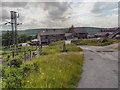
Castle Lane, Micklehurst, Mossley
Looking north down Castle Lane towards Micklehurst. Mossley Hollins High School can be seen just right of centre.
Image: © Martin Clark
Taken: Unknown
0.06 miles
5
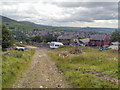
Pennine Bridleway
Heading towards Carrbrook.
Image: © David Dixon
Taken: 27 Jun 2012
0.07 miles
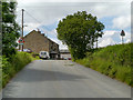
6
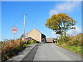
Approaching Castle Cottages and Farm
Castle Lane, Carrbrook.
Image: © John Topping
Taken: 4 Nov 2013
0.08 miles
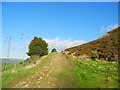
7
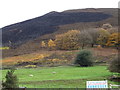
Hillside grazing near Castle Farm
Moorland behind was damaged by the fires of 2018.
Image: © JThomas
Taken: 8 Nov 2018
0.08 miles
8
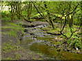
Castle Clough, Staly Brook
The wooded valley (clough) below Buckton Castle.
Image: © David Dixon
Taken: 27 Jun 2012
0.08 miles
9
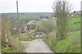
Castle Lane
Looking up Castle Lane, towards Castle Farm.
Image: © David Dixon
Taken: 27 Jun 2012
0.08 miles
10
Moor Edge Road (Pennine Bridleway)
North of Castle Farm.
Image: © John Topping
Taken: 4 Nov 2013
0.10 miles