IMAGES TAKEN NEAR TO
Pear Tree Drive, STALYBRIDGE, SK15 2PY
Introduction
This page details the photographs taken nearby to Pear Tree Drive, SK15 2PY by members of the Geograph project.
The Geograph project started in 2005 with the aim of publishing, organising and preserving representative images for every square kilometre of Great Britain, Ireland and the Isle of Man.

There are currently over 7.5m images from over14,400 individuals and you can help contribute to the project by visiting https://www.geograph.org.uk
Image Map
Images are licensed for reuse under creativecommons.org/licenses/by-sa/2.0
Notes
- Clicking on the map will re-center to the selected point.
- The higher the marker number, the further away the image location is from the centre of the postcode.
Image Listing (76 Images Found)
Images are licensed for reuse under creativecommons.org/licenses/by-sa/2.0
Image
Details
Distance
1
The Spindles.
Near canal wildlife residence.
Image: © Andrew Burrows
Taken: 15 Jun 2023
0.07 miles
2
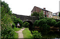
Stalybridge: Huddersfield Narrow Canal: Site of Bridge 98
This would have been the bridge carrying the now-lifted Stalybridge to Diggle loop, sometimes known as the Micklehurst loop. It originally had four stations, which from the Stalybridge end, were Staley & Millbrook, Micklehurst, Friezland, and Upper Mill (sic). But these were all closed long ago, before the First World War. The line continued to be used for freight and for the odd through passenger train diverted this way, until 1966, but was not lifted for some time after that.
Image: © Dr Neil Clifton
Taken: 10 Jul 2010
0.09 miles
3
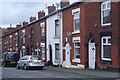
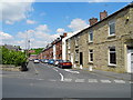
Tatton Street, Stalybridge
A row of traditional 'two up two down' terraced houses lines Tatton Street as it drops into the Tame Valley.
Image: © Stephen McKay
Taken: 18 Feb 2020
0.10 miles
4
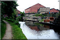
The Wooden Canal Boat Society at Stalybridge
See; http://wcbs.org.uk/
Image: © Chris Morgan
Taken: 18 Mar 2019
0.11 miles
5

Lockside houses, Stalybridge
What was the reaction of the residents when the canal was restored?
Image: © Christine Johnstone
Taken: 17 May 2010
0.11 miles
6

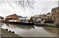
Canalside apartments, Stalybridge
These have been built along one side of the winding hole above Lock 7W.
Image: © Christine Johnstone
Taken: 17 May 2010
0.11 miles
7
Lindsay Street, Stalybridge
Viewed from Stocks Lane.
Image: © John Topping
Taken: 26 May 2013
0.11 miles
8

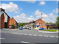
Waves and Curls
Hairdressers on the corner of Mottram Road and Huddersfield Road.
Image: © Gerald England
Taken: 24 Mar 2011
0.12 miles
9
Tatton Street, Stalybridge
Viewed from Stocks Lane.
Image: © John Topping
Taken: 26 May 2013
0.12 miles
10
Stalybridge: Huddersfield Narrow Canal: Bridge 97
Looking west. This bridge carries a footpath, possibly useable as a cart-track.
Image: © Dr Neil Clifton
Taken: 10 Jul 2010
0.12 miles