IMAGES TAKEN NEAR TO
Spring Bank, STALYBRIDGE, SK15 2EQ
Introduction
This page details the photographs taken nearby to Spring Bank, SK15 2EQ by members of the Geograph project.
The Geograph project started in 2005 with the aim of publishing, organising and preserving representative images for every square kilometre of Great Britain, Ireland and the Isle of Man.

There are currently over 7.5m images from over14,400 individuals and you can help contribute to the project by visiting https://www.geograph.org.uk
Image Map
Images are licensed for reuse under creativecommons.org/licenses/by-sa/2.0
Notes
- Clicking on the map will re-center to the selected point.
- The higher the marker number, the further away the image location is from the centre of the postcode.
Image Listing (69 Images Found)
Images are licensed for reuse under creativecommons.org/licenses/by-sa/2.0
Image
Details
Distance
1
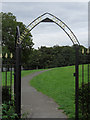
Cheetham Park, Stalybridge
A new ornate entrance at the western end of Forester Drive.
Image: © michael ely
Taken: 23 Aug 2008
0.03 miles
2
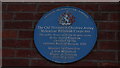
Stalybridge - Plaque to the former public house with longest name in Britain
The former 'The Old Thirteenth Cheshire Astley Volunteer Rifleman Corps Inn' had a claim to fame as being the longest pub name in Britain. It is no longer a public house but a private dwelling although this plaque remains on the building.
Image: © Colin Park
Taken: 24 Feb 2018
0.09 miles
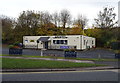
5
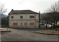
The (former) Pineapple
Former Robinsons pub on the corner of High Street and Kenworthy Street. Compare with view in 2013 Image when plans to turn it into an Islamic centre for education and prayer were turned down https://www.manchestereveningnews.co.uk/news/greater-manchester-news/plans-build-stalybridge-tameside-mosque-6310947 I'm given to understand it will now probably be converted into housing.
Image: © Gerald England
Taken: 20 Jul 2018
0.17 miles
6
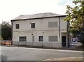
The (former) Pineapple
Former Robinsons pub on High Street de-signed and boarded up.
Image: © Gerald England
Taken: 4 Mar 2013
0.17 miles
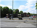
7
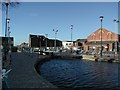
Stalybridge
The new Huddersfield Narrow canal lock in the rejuvenated town square in the centre of Stalybridge
Image: © David Stowell
Taken: 10 Jan 2001
0.19 miles
8
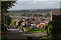
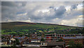
The top of Hough Hill Road
Residential properties extend quite a long way up this hill. The large building opposite is Tameside General Hospital while mill refurbishment continues in the centre of Stalybridge at the bottom of the valley.
Image: © Bill Boaden
Taken: 5 Oct 2010
0.19 miles
9
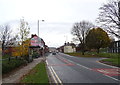
Acres Lane, Stalybridge
Looking north east on the B6175.
Image: © JThomas
Taken: 8 Nov 2018
0.19 miles
10
Stalybridge
Stalybridge seen from the station.
Image: © Peter McDermott
Taken: 9 Aug 2013
0.20 miles