IMAGES TAKEN NEAR TO
Rydal Avenue, HYDE, SK14 4XT
Introduction
This page details the photographs taken nearby to Rydal Avenue, SK14 4XT by members of the Geograph project.
The Geograph project started in 2005 with the aim of publishing, organising and preserving representative images for every square kilometre of Great Britain, Ireland and the Isle of Man.

There are currently over 7.5m images from over14,400 individuals and you can help contribute to the project by visiting https://www.geograph.org.uk
Image Map
Images are licensed for reuse under creativecommons.org/licenses/by-sa/2.0
Notes
- Clicking on the map will re-center to the selected point.
- The higher the marker number, the further away the image location is from the centre of the postcode.
Image Listing (99 Images Found)
Images are licensed for reuse under creativecommons.org/licenses/by-sa/2.0
Image
Details
Distance
1
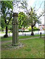
What is this?
This object is located near the junction of Lower Bennett Street and Arnside Drive. See 2012 photograph from opposite direction Image I'd always surmised it was originally a gatepost but someone recently suggested it might have been a chimney which was used as a ventilation shaft for the local mine workings. Others have said it could be a guide-post. Local enquiries now appear to indicate that it was just a decorative looking pillar that council workmen had found lying around and thought that it would be a nice thing to stick there for people to admire. It seems to have appeared sometime in the 1980s.
Image: © Gerald England
Taken: 29 May 2016
0.08 miles
2
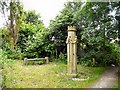
Bench and Gatepost
Just by a footpath that cuts the corner between Lower Bennett Street and Dukinfield Road is a little bench and this castellated gatepost. I've so far been unable to discover its origin.
Image: © Gerald England
Taken: 21 Jul 2012
0.08 miles
3
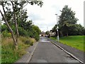
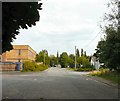
Arnside Drive
Off Lower Bennett Street.
Image: © Gerald England
Taken: 21 Jul 2012
0.08 miles
4
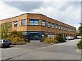
Frederick House
Social Care & Health offices of Tameside Metropolitan Borough on Dunkirk Lane.
Image: © Gerald England
Taken: 6 May 2012
0.08 miles
5
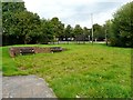
Newton Hall after the dig
The grounds of Newton Hall restored after the dig earlier in the year.
Image: © Gerald England
Taken: 9 Sep 2012
0.09 miles
6
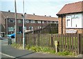
Corner of Kirkstone Road and Windermere Road
Image: © Gerald England
Taken: 29 Mar 2014
0.10 miles
7
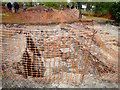
Dig at Newton Hall
A section of the 2012 archaeological dig at Newton Hall.
Image: © Gerald England
Taken: 6 May 2012
0.10 miles
8
Dunkirk Lane
On the left is Frederick House Image On the right is the 14th century Newton Hall Image In the background is the spire of St Stephen's Church Image
Image: © Gerald England
Taken: 9 Sep 2012
0.10 miles
9
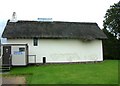
Newton Hall
The rescued cruck framed part of the original hall used apparently as a barn on the farm that developed on the hall site.
Image: © Kevin Waterhouse
Taken: 30 May 2023
0.10 miles
10
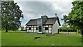
Rear of Newton Hall
Constructed in 1370; restored in 1970.
Front view: Image
Image: © Gerald England
Taken: 9 Sep 2007
0.10 miles