IMAGES TAKEN NEAR TO
Hattersley Road West, HYDE, SK14 3LJ
Introduction
This page details the photographs taken nearby to Hattersley Road West, SK14 3LJ by members of the Geograph project.
The Geograph project started in 2005 with the aim of publishing, organising and preserving representative images for every square kilometre of Great Britain, Ireland and the Isle of Man.

There are currently over 7.5m images from over14,400 individuals and you can help contribute to the project by visiting https://www.geograph.org.uk
Image Map
Images are licensed for reuse under creativecommons.org/licenses/by-sa/2.0
Notes
- Clicking on the map will re-center to the selected point.
- The higher the marker number, the further away the image location is from the centre of the postcode.
Image Listing (74 Images Found)
Images are licensed for reuse under creativecommons.org/licenses/by-sa/2.0
Image
Details
Distance
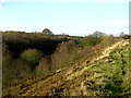
1
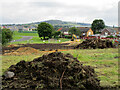
Hattersley Science and Technology Park
Work starting clearing the site for Hattersley Science and Technology Park, this involved the felling of a dozen or so trees on this greenfield site. Envirolab a soil testing business will be relocating from the Sand Pitts Industrial Estate and is the main driver of this project.
Image: © Stephen Burton
Taken: 8 Jul 2021
0.08 miles
2
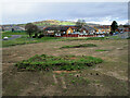
Hattersley Science and Technology Park
Trees were felled and the land was cleared in July 2021 but since then no progress has been made on the construction of the Science Park. View of the site in 2021 https://www.geograph.org.uk/photo/6893918
Image: © Stephen Burton
Taken: 23 Feb 2022
0.10 miles
3
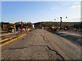
Sandy Bank Avenue
New housing development on Sandy Bank Avenue. This site has been vacant for about 20 years since the demolition of shops and a public house (The Centurion) When completed it will provide about 75 homes. https://www.barratthomes.co.uk/new-homes/greater-manchester/h777801-weavers-place/
Image: © Stephen Burton
Taken: 11 Apr 2019
0.10 miles
4
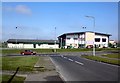
Ken Ward Sports Centre
Opened in 2006 on the site of the former Hattersley High School.
Image: © Gerald England
Taken: 22 Mar 2011
0.11 miles
5
Railway Cutting, Hattersley
This cutting on the Manchester to Glossop line started out life as a tunnel but was later opened up into this steep sided cutting. It forms the S.W border of the Hattersley estate. Taken at 12noon Christmas day.
Image: © Stephen Burton
Taken: 25 Dec 2005
0.11 miles
6
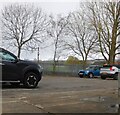
British Gas Depot car park
The site on the Hattersley Industrial Estate was being used as a drive-in centre for the administration of Covid vaccine boosters.
Image: © Gerald England
Taken: 9 Apr 2022
0.12 miles
7
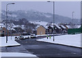
Hattersley Road West
The junction of Chapman road with Hattersley road Werneth Low can be seen in the background.
Image: © Stephen Burton
Taken: 21 Feb 2010
0.12 miles
8
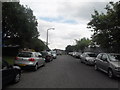
Street in Hattersley Industrial Estate
Image: © Anthony Parkes
Taken: 19 Jul 2010
0.13 miles
9

Towards Manchester on the Woodhead main line in Hattersley Cutting
A local train from Manchester London Road to Hadfield passes far below while a westbound coal train recedes towards Godley Junction. The local is headed by ex-GC Robinson class 9K (LNER C13) 4-4-2T No. 67437, built 5/1905 as No. 114 (LNER No. 5114, No. 7437 from 1946), withdrawn 8/57. (See Image] for more detail).
Image: © Ben Brooksbank
Taken: 28 Jul 1951
0.13 miles
10
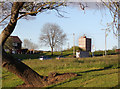
Hattersley
The Hattersley estate was constructed in the early 1960s. In recent years a major renovation of the area as been undertaken, this has improved the area significantly. The Centurion public house once stood on this plot it was demolished in around 1999. The tower block in the background is the last high-rise block remaining; the other seven were demolished in 2001. http://www.youtube.com/watch?v=nCvDHWgDX6c
Image: © Stephen Burton
Taken: 16 May 2012
0.13 miles