IMAGES TAKEN NEAR TO
Howard Place, HYDE, SK14 2TB
Introduction
This page details the photographs taken nearby to Howard Place, SK14 2TB by members of the Geograph project.
The Geograph project started in 2005 with the aim of publishing, organising and preserving representative images for every square kilometre of Great Britain, Ireland and the Isle of Man.

There are currently over 7.5m images from over14,400 individuals and you can help contribute to the project by visiting https://www.geograph.org.uk
Image Map
Images are licensed for reuse under creativecommons.org/licenses/by-sa/2.0
Notes
- Clicking on the map will re-center to the selected point.
- The higher the marker number, the further away the image location is from the centre of the postcode.
Image Listing (2538 Images Found)
Images are licensed for reuse under creativecommons.org/licenses/by-sa/2.0
Image
Details
Distance
1
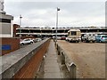
Footpath from Travis Street
The footpath links Travis Street to one of the entrances to the Clarendon Shopping Centre. The cars on the left are in the disabled parking section outside the entrance. On the right is a council-owned pay and display car park. The upper floors of the multi-storey car park in the background are free during normal shopping hours and closed outside those hours.
Image: © Gerald England
Taken: 13 Mar 2010
0.01 miles
2
Entrance to John Grundy House
The entrance to John Grundy House (a block of flats named after an ex-Mayor) and the entrance to Clarendon Shopping Centre from the car park.
Image: © Gerald England
Taken: 7 Nov 2011
0.01 miles
3
John Grundy House from Union Street
John Grundy House (named after a former mayor of Hyde) is an apartment block rising above the Clarendon Square Shopping Centre. Clarendon Place is now visible following the demolition of the multi-storey car park. Compare with the view in March 2013 Image and March 2014 Image
Image: © Gerald England
Taken: 30 Apr 2014
0.01 miles
4
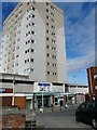
John Grundy House
The block of flats above the Clarendon Shopping Centre is named after John Grundy, a former mayor of Hyde.
Image: © Gerald England
Taken: 18 Mar 2008
0.01 miles
5
Entrance to Clarendon Square Shopping Centre
The entrance from the car park is still sealed off after being attacked by ram-raiders several weeks ago.
Image: © Gerald England
Taken: 4 Feb 2021
0.01 miles
6
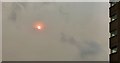
Ophelia's sun
The remnants of Hurricane Ophelia - which caused devastation in Ireland and Wales - had drawn tropical air containing Saharan dust and debris from forest fires in Spain and Portugal over parts of the British Isles. The sky was a peculiar pink, red or orange shade with a strong bright sun trying to break through. On the right are apartments in John Grundy House.
Ground View: Image
Image: © Gerald England
Taken: 16 Oct 2017
0.01 miles
7

John Grundy House
Hi-rise apartments above the Clarendon Shopping Centre. It is named after John Grundy a former mayor of Hyde. The multi-storey car park on the left is due to be demolished and replaced by a Kentucky Fried Chicken outlet.
Image: © Gerald England
Taken: 28 Oct 2013
0.01 miles
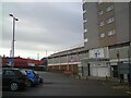
8
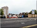
Delivery and Demolition
On the left a Fultons Food lorry is delivering in Service Yard 3 of the Clarendon Square Shopping Centre. On the right a workman is sweeping rubble back inside the demolition site of the multi-storey car park.
Image: © Gerald England
Taken: 26 Apr 2014
0.01 miles
9
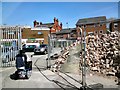
Access to Clarendon Place
Access from the Clarendon Square Shopping Centre to Clarendon Place. On the left is Service Yard #3. On the right is rubble from the recently demolished multi storey car park. Compare with the view four days earlier Image
Image: © Gerald England
Taken: 3 May 2014
0.01 miles
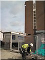
10
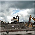
On top of the job
Demolition contractors busy clearing the rubble of the former Clarendon Square multi-storey car park.
Image: © Gerald England
Taken: 9 May 2014
0.02 miles