IMAGES TAKEN NEAR TO
Woodbrooke Avenue, HYDE, SK14 2SQ
Introduction
This page details the photographs taken nearby to Woodbrooke Avenue, SK14 2SQ by members of the Geograph project.
The Geograph project started in 2005 with the aim of publishing, organising and preserving representative images for every square kilometre of Great Britain, Ireland and the Isle of Man.

There are currently over 7.5m images from over14,400 individuals and you can help contribute to the project by visiting https://www.geograph.org.uk
Image Map
Images are licensed for reuse under creativecommons.org/licenses/by-sa/2.0
Notes
- Clicking on the map will re-center to the selected point.
- The higher the marker number, the further away the image location is from the centre of the postcode.
Image Listing (264 Images Found)
Images are licensed for reuse under creativecommons.org/licenses/by-sa/2.0
Image
Details
Distance
1
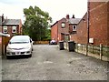
Winfield Street
Off Grange Road North and leading to Woodbrook Avenue.
Image: © Gerald England
Taken: 11 Jul 2015
0.02 miles
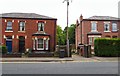
2
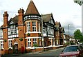
Bankfield Hotel
Closed at the moment, the Bankfield is on the A57. At one time this was the main road from Manchester to Sheffield. Older photographs https://hydonian.blogspot.com/2010/08/bankfield-hotel.html
Image: © Stephen Burton
Taken: 2 Jun 2005
0.06 miles
3
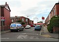
Miles Street
Parking on Miles Street is restricted to residents due to its proximity to Ewen Fields, the home ground of Hyde United, which can be seen in the background.
Image: © Gerald England
Taken: 29 Aug 2009
0.06 miles
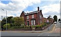
5
Ewen Villa
Large house dated 1876 at the top of Villiers Street.
See the villa from the other direction: Image
Image: © Gerald England
Taken: 29 Aug 2009
0.07 miles
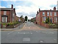
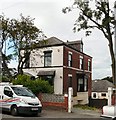
6
Victorian House on Mottram Road
This large house on the corner of Grange Road North Road Image dates from 1887.
Image: © Gerald England
Taken: 23 Jun 2015
0.07 miles
7
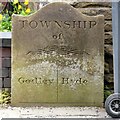
Godley/Hyde Township boundary stone
This boundary stone between the Townships of Godley and Hyde is on Mottram Road. It stands in front of the wall of #186 Mottram Road Image
It is similar to Werneth/Bredbury boundary stone Image and the Hyde/Werneth boundary stone Image
Image: © Gerald England
Taken: 23 Jun 2015
0.07 miles
8
Godley and Hyde Boundary
In front of the wall of #196 Mottram Road almost hidden by a wheelie-bin is the boundary stone Image between the Townships of Godley and Hyde.
Image: © Gerald England
Taken: 23 Jun 2015
0.07 miles
9
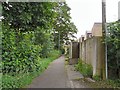
Tinker's Passage
Footpath at the rear of Miles Street leading from Ewen Fields to Grange Road North.
Image: © Gerald England
Taken: 26 Jun 2012
0.07 miles
10
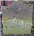
Old Boundary Marker by the A57, Mottram Road, Hyde parish
Parish Boundary Marker by the A57, in parish of Hyde (Tameside District), Mottram Road, against brick wall at back of pavement outside 196 Mottram Road, South side of road.
Inscription reads:-
TOWNSHIP
of
GODLEY | HYDE
Surveyed
Milestone Society National ID: CH_HYDGOD01pb
Image: © Milestone Society
Taken: Unknown
0.08 miles