IMAGES TAKEN NEAR TO
Henry Street, HYDE, SK14 1JL
Introduction
This page details the photographs taken nearby to Henry Street, SK14 1JL by members of the Geograph project.
The Geograph project started in 2005 with the aim of publishing, organising and preserving representative images for every square kilometre of Great Britain, Ireland and the Isle of Man.

There are currently over 7.5m images from over14,400 individuals and you can help contribute to the project by visiting https://www.geograph.org.uk
Image Map
Images are licensed for reuse under creativecommons.org/licenses/by-sa/2.0
Notes
- Clicking on the map will re-center to the selected point.
- The higher the marker number, the further away the image location is from the centre of the postcode.
Image Listing (2127 Images Found)
Images are licensed for reuse under creativecommons.org/licenses/by-sa/2.0
Image
Details
Distance
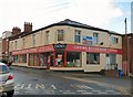
1
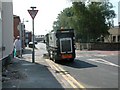
Cleaning Henry Street
A street cleaning vehicle on Henry Street at its junction with Church Street.
Image: © Gerald England
Taken: 26 Jul 2006
0.02 miles
2
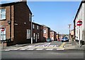
No Entry
Henry Street is a one-way street and there is No Entry from Church Street. The white lines have recently been redone to emphasise the fact.
Image: © Gerald England
Taken: 13 May 2016
0.02 miles
3
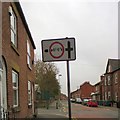
Church Street
Approaching the junction with Henry Street. The road sign indicates that the road on the left has a width restriction of 6' 6" Image
Image: © Gerald England
Taken: 28 Apr 2015
0.02 miles
4
Church Street
Towards Market Street from the junction with Henry Street.
Image: © Gerald England
Taken: 16 Jul 2009
0.02 miles
5
Crown Decorator Centre
One of around 115 centres in the UK supplying to the trade.
Image: © Gerald England
Taken: 21 Feb 2015
0.03 miles
6
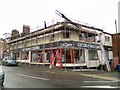
Crown Decorating Centre
Covered in scaffold. I'm not sure if they are doing work on the roof or decorating.
Image: © Gerald England
Taken: 15 Nov 2016
0.03 miles
7
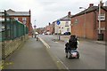
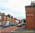
Pinch-point on Henry Street
Henry Street and its continuation Higher Henry Street used to be used as a "rat run" (as such routes are called) for traffic between Dowson Road and Manchester Road wanting to avoid the main road through the town centre.
The "traffic-calming" measures introduced some years ago involved creating a "pinch-point" here where the road is reduced to 6 feet 6 inches width to prevent HGVs accessing the road. Various sections were made "one-way" so it became no longer a direct "through-route".
Wheelchair users are often forced to use the road as the pavements are blocked by parked cars and wheelie-bins.
Image: © Gerald England
Taken: 6 May 2015
0.03 miles
8
The corner of Church Street and Henry Street
Behind the wall and fencing is a classroom belonging to the present St George's Church of England Primary School. The stone wall is part of the 1913 extension Image to the 1870 "New" school" that replaced the original school which dated from 1836. The old buildings were replaced by modern classrooms in 1978.
For more information on the history of the school see http://hydonian.blogspot.co.uk/2012/06/st-georges-school.html
Image: © Gerald England
Taken: 11 Jun 2016
0.03 miles
9
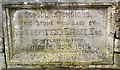
1913 School Extensions
The stone on the wall facing Church Street Image marks the 1913 extension to the 1870 "New" school" that replaced the original St George's school which dated from 1836. It was laid by J Leadbitter Knott Esq of Wylam-on-Tyne, October 25th 1913.
Image: © Gerald England
Taken: 11 Jun 2016
0.03 miles
10
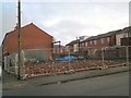
Site of the original Hyde Grammar School
The site of the original school on Henry Street Image has been reduced entirely to rubble.
Image: © Gerald England
Taken: 21 Jan 2019
0.03 miles