IMAGES TAKEN NEAR TO
Union Street, STOCKPORT, SK1 3NP
Introduction
This page details the photographs taken nearby to Union Street, SK1 3NP by members of the Geograph project.
The Geograph project started in 2005 with the aim of publishing, organising and preserving representative images for every square kilometre of Great Britain, Ireland and the Isle of Man.

There are currently over 7.5m images from over14,400 individuals and you can help contribute to the project by visiting https://www.geograph.org.uk
Image Map
Images are licensed for reuse under creativecommons.org/licenses/by-sa/2.0
Notes
- Clicking on the map will re-center to the selected point.
- The higher the marker number, the further away the image location is from the centre of the postcode.
Image Listing (478 Images Found)
Images are licensed for reuse under creativecommons.org/licenses/by-sa/2.0
Image
Details
Distance
1
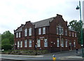
Millbrook Centre
Day centre attached to Image
Image: © Gerald England
Taken: 17 Aug 2013
0.02 miles
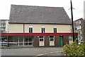
2
Windlehurst School, Millbrook site
The former Millbrook day centre Image and the former Stockport Fog Pentecostal Church Image is now a part of Windlehurst School. Windlehurst School operates on 2 sites. The larger site in Hawk Green accommodates students in Years 7 and 8 and older students who are following GCSE courses. The site at Millbrook Street is used as a base for students who respond to a more practical curriculum. The Millbrook Street site is used mainly, but not exclusively, by pupils at KS4. http://www.windlehurst.stockport.sch.uk/parents-and-carers/school-information
Image: © Gerald England
Taken: 25 Jul 2017
0.02 miles
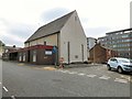
3
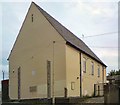
Stockport Fog Pentecostal Church
The Ratcliffe Street gable end of the Stockport Fog Pentecostal Church (African Revival & Worldwide Family of God Churches, [Apostolic]) on Millbrook Street, rebuilt in 1960 and now part of the Millbrook Centre Image
Image: © Gerald England
Taken: 17 Aug 2013
0.03 miles
4
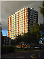
Towerblock, Stockport
The view from Millbrook Street of one of a number of similar blocks.
Image: © Andrew Smith
Taken: 20 Jul 2008
0.03 miles
5

Millbrook Towers from Ratcliffe Street
Millbrook Street runs across the end of Ratcliffe Street. The changing colours on the facade of the block of flats are a property of the cladding. It's called 'Chameleon' cladding and is made by a company called Rockpanel. The company's website explains: "The ROCKPANEL Chameleon range is finished with a unique crystal layer which, depending on the angle from which it’s viewed and the effect of light, appears to dramatically change colour." The panels are available in four different colour-change palettes: green - light grey - pink; green - grey - pink; orange - green - brown; and purple - blue - green. http://www.rockpanel.co.uk/products/rockpanel%20chameleon
Image: © Robin Stott
Taken: 17 Aug 2013
0.04 miles
6
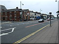
Wellington Road South, Stockport (A6)
Heading south.
Image: © JThomas
Taken: 24 May 2014
0.04 miles
7
Pedestrian Crossing on Wellington Road
Image: © Eirian Evans
Taken: 14 Jun 2023
0.04 miles
8
Landscaping below Millbrook Towers, Millbrook Street
Viewed from many floors up in a housing development, landscaping using large-scale shapes creates a sense of place.
Image: © Robin Stott
Taken: 17 Aug 2013
0.05 miles
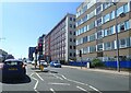
9
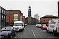
St Thomas's Place, Stockport
The road is dominated by St Thomas's Church, a Grade I listed Anglican church. However the current state of the road does not set it off to best advantage.
Image: © Bill Boaden
Taken: 12 Mar 2015
0.06 miles