IMAGES TAKEN NEAR TO
Old Cross, GLOSSOP, SK13 7RX
Introduction
This page details the photographs taken nearby to Old Cross, SK13 7RX by members of the Geograph project.
The Geograph project started in 2005 with the aim of publishing, organising and preserving representative images for every square kilometre of Great Britain, Ireland and the Isle of Man.

There are currently over 7.5m images from over14,400 individuals and you can help contribute to the project by visiting https://www.geograph.org.uk
Image Map (Loading...)


Getting Data...Please wait
Leaflet Map data © OpenStreetMap
Images are licensed for reuse under creativecommons.org/licenses/by-sa/2.0
Notes
- Clicking on the map will re-center to the selected point.
- The higher the marker number, the further away the image location is from the centre of the postcode.
Image Listing (93 Images Found)
Images are licensed for reuse under creativecommons.org/licenses/by-sa/2.0
Image
Details
Distance
1
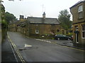
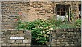
Church Street South, Old Glossop
The cottages on the hill date back to the 17th Century.
Image: © Benjamin Hopkins
Taken: 26 Jul 2010
0.01 miles
2
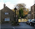
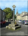
Old Cross
During the mediaeval period, from 1157 to the late 15th century, the lordship rights over the lands around Glossop belonged to Basingwerk Abbey in North Wales. Monks from Basingwerk farmed around Charlesworth, and several times Monks found themselves in court in Glossop for poaching. The monks set up crosses at a number of locations around Glossop to mark the boundaries of the area they held.
One of these crosses stood at Old Glossop, and indeed most of it still does.
The cross-shaft is said to date from 1290, but the cross on top is a relatively modern addition. The cross has also moved to the centre of the road. Old photographs can be viewed on the Old Glossop website https://web.archive.org/web/20120718025058/http://www.old-glossop.com/pages/map/mannorhouse1.html (archive page)
Image: © Gerald England
Taken: 17 Nov 2009
0.01 miles
3
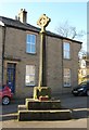
Old Central Cross by Old Cross, Old Glossop
Old Glossop Cross, old shaft and base by the wayside, in parish of Glossop (High Peak District), off Church Street, Old Glossop Market Cross, two shafts- Saxon brought here from Ollerenshaw Hall in 20th century.
Grade II Listed. List Entry Number: 1384239
https://historicengland.org.uk/listing/the-list/list-entry/1384239
To be surveyed
Milestone Society National ID: DEHP_GLO01
Image: © Milestone Society
Taken: Unknown
0.01 miles
4
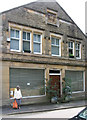
Glossop - Co-op
At one time, this was a branch of the Glossopdale Co-op on Church Street South, Old Glossop.
Image: © Dave Bevis
Taken: 22 Aug 2010
0.01 miles
5
Old Cross, Old Glossop
In the centre of Old Glossop.
Image: © D Williams
Taken: Unknown
0.01 miles
7
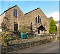
Wesleyan School
Erected in 1824 and rebuilt in 1876. Presently it is used as offices but there is a planning application to convert it into two residences.
Image: © Gerald England
Taken: 17 Nov 2009
0.02 miles
8
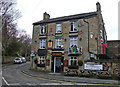
The Queens, Old Glossop
One of three pubs in Old Glossop. This one is on the corner of Shepley Street and Church Street South. The christmas decorations are still in place on the first day of spring.
Image: © michael ely
Taken: 21 Mar 2011
0.02 miles
9
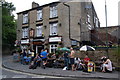
The Queens, Old Glossop
After a long walk when most of us had run out of water, this was about as welcome a sight as you could hope to see. The Black Sheep was especially nice.
Image: © Bill Boaden
Taken: 27 Jun 2009
0.02 miles
10
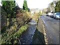
Blackshaw Brook
The brook flowing from Blackshaw Clough alongside Wesley Street. The brook flows into Shelf Brook a little further South.
Image: © Gerald England
Taken: 17 Nov 2009
0.02 miles