IMAGES TAKEN NEAR TO
Manor Park Road, GLOSSOP, SK13 7GD
Introduction
This page details the photographs taken nearby to Manor Park Road, SK13 7GD by members of the Geograph project.
The Geograph project started in 2005 with the aim of publishing, organising and preserving representative images for every square kilometre of Great Britain, Ireland and the Isle of Man.

There are currently over 7.5m images from over14,400 individuals and you can help contribute to the project by visiting https://www.geograph.org.uk
Image Map
Images are licensed for reuse under creativecommons.org/licenses/by-sa/2.0
Notes
- Clicking on the map will re-center to the selected point.
- The higher the marker number, the further away the image location is from the centre of the postcode.
Image Listing (47 Images Found)
Images are licensed for reuse under creativecommons.org/licenses/by-sa/2.0
Image
Details
Distance
1
Manor Park
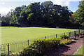
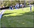
Manor Park was formed from the ornamental grounds of a house owned by the Dukes of Norfolk. The house itself has gone but the grounds were opened to the public in 1927. This view shows the bowling green.
Image: © Stephen McKay
Taken: 2 Oct 2024
0.05 miles
2
Manor Park
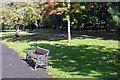
Autumn colours are beginning to appear in this early October view. Manor Park was formed from the ornamental grounds of a house owned by the Dukes of Norfolk. The house itself has gone but the grounds were opened to the public in 1927.
Image: © Stephen McKay
Taken: 2 Oct 2024
0.06 miles
3
Manor Park
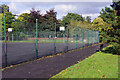
Manor Park was formed from the ornamental grounds of a house owned by the Dukes of Norfolk. The house itself has gone but the grounds were opened to the public in 1927. This view shows the tennis courts on the eastern side of the park.
Image: © Stephen McKay
Taken: 2 Oct 2024
0.06 miles
4
Miniature Railway Track
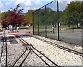
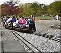
The track of the miniature railway at Manor Park.
Image: © Gerald England
Taken: 8 May 1994
0.06 miles
5
Manor Park
Manor Park from the miniature railway.
Image: © Gerald England
Taken: 8 May 1994
0.08 miles
6
Manor Park Miniature Railway
The miniature railway at Manor Park.
Image: © Gerald England
Taken: 8 May 1994
0.08 miles
7

Glossop - Sheffield Road from Shire Hill
This photo towards the houses on Sheffield Road was taken from the footpath along the western base of Shire Hill. Towards the right of the photo can be seen Howardtown Mills (see Image for close-up) and in the top right can be seen Cown Edge.
Image: © Dave Bevis
Taken: 22 Aug 2010
0.08 miles
8
End of the ride
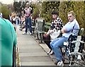
Platform for the Manor Park Miniature Railway.
Image: © Gerald England
Taken: 8 May 1994
0.08 miles
9
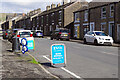
Manor Park Road, Glossop
Manor Park Road leads up from High Street East to Old Glossop; this view is from near the bottom end. There is a Go Local Extra convenience store out of shot to the left that also acts as an Evri parcel shop. Evri was previously known as Hermes but the name was changed as a response to its reputation for poor customer service and questionable employment practices.
Image: © Stephen McKay
Taken: 2 Oct 2024
0.10 miles
10
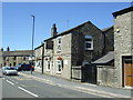
The Commercial Inn, Glossop
On the junction of Sheffield Road and Manor Park Road.
Image: © JThomas
Taken: 30 Jun 2018
0.11 miles