IMAGES TAKEN NEAR TO
Hargate Hill, GLOSSOP, SK13 6JL
Introduction
This page details the photographs taken nearby to Hargate Hill, SK13 6JL by members of the Geograph project.
The Geograph project started in 2005 with the aim of publishing, organising and preserving representative images for every square kilometre of Great Britain, Ireland and the Isle of Man.

There are currently over 7.5m images from over14,400 individuals and you can help contribute to the project by visiting https://www.geograph.org.uk
Image Map
Images are licensed for reuse under creativecommons.org/licenses/by-sa/2.0
Notes
- Clicking on the map will re-center to the selected point.
- The higher the marker number, the further away the image location is from the centre of the postcode.
Image Listing (15 Images Found)
Images are licensed for reuse under creativecommons.org/licenses/by-sa/2.0
Image
Details
Distance
1
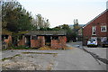
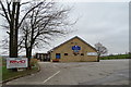
Old stables at Hargate Hill Farm
The farm is an equestrian centre and has plenty of newer stables. These are used for storage.
Image: © Bill Boaden
Taken: 13 Oct 2010
0.01 miles
2
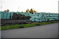
A full larder at Hargate Hill Farm
Being a large equestrian centre, there is plenty of demand for food for the horses.
Image: © Bill Boaden
Taken: 13 Oct 2010
0.09 miles
3
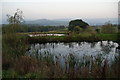
Fishing ponds at Hargate Hill Farm
This is looking over Dinting Vale to Mouselow.
Image: © Bill Boaden
Taken: 13 Oct 2010
0.12 miles
4
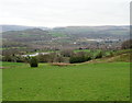
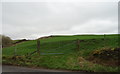
Grazing, Hargate Hill
View down the valley from High Lane.
Image: © JThomas
Taken: 21 Mar 2019
0.15 miles
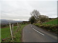
6
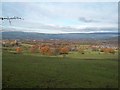
Hargate Hill
Looking down Hargate Hill from High Lane.
Image: © David Dixon
Taken: 23 Nov 2012
0.18 miles
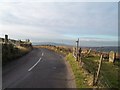
7
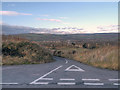
Towards Dinting Vale from High Lane
Looking north on a fine and cold Saturday in late November.
Image: © Jonathan Clitheroe
Taken: 23 Nov 2013
0.19 miles
8
High Lane towards Glossop
Looking east along the ridge.
Image: © JThomas
Taken: 21 Mar 2019
0.19 miles
9
Junction of High Lane and Hargate Hill Lane
Image: © Jonathan Clitheroe
Taken: 23 Nov 2013
0.20 miles