IMAGES TAKEN NEAR TO
Hillside Close, GLOSSOP, SK13 2EB
Introduction
This page details the photographs taken nearby to Hillside Close, SK13 2EB by members of the Geograph project.
The Geograph project started in 2005 with the aim of publishing, organising and preserving representative images for every square kilometre of Great Britain, Ireland and the Isle of Man.

There are currently over 7.5m images from over14,400 individuals and you can help contribute to the project by visiting https://www.geograph.org.uk
Image Map
Images are licensed for reuse under creativecommons.org/licenses/by-sa/2.0
Notes
- Clicking on the map will re-center to the selected point.
- The higher the marker number, the further away the image location is from the centre of the postcode.
Image Listing (24 Images Found)
Images are licensed for reuse under creativecommons.org/licenses/by-sa/2.0
Image
Details
Distance
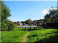
1
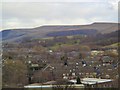
New Year, New Picture
This view takes in much of the square, being shot, just after noon, from an elevated location on the western boundary. The old homestead is on the extreme left of shot, about middle height, just by the tree :) Happy New Year 2006!
Image: © Roger May
Taken: 1 Jan 2006
0.06 miles
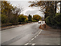
4
Tavern Road, Hadfield
Viewed from the junction with Woolley Bridge A57.
Image: © John Topping
Taken: 29 Sep 2013
0.20 miles
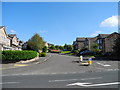
5
Springfield Close, Hadfield
Viewed from the Trans Pennine Trail.
Image: © John Topping
Taken: 29 Sep 2013
0.20 miles
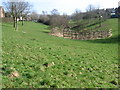
8
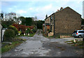
Shepley Street
A short unadopted lane off Brookfield. Classed as Glossop, not Hadfield. Has just five properties. Number 1 is a corner terrace out of shot to the left, visible are numbers 4,6 and 8. Hidden behind them is a fine manse.
Image: © David Lally
Taken: 10 Nov 2010
0.20 miles
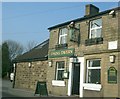
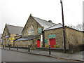
9
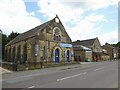
Former Congregational Chapel
Now part of a timber & DIY business along the A57 at Brookfield. Beyond the chapel is a former school which is used by the same business.
Image: © Kevin Waterhouse
Taken: 8 Jul 2024
0.21 miles
10

Old Boundary Marker by the A57, Woolley Bridge, Glossop parish
County Boundary Marker by the A57, in parish of Glossop (High Peak District), opposite the former Spring Tavern, now private housing, on the West side of the A57, Woolley Bridge.
Surveyed
Milestone Society National ID: DE_SFMCcb
Image: © Milestone Society
Taken: Unknown
0.21 miles