IMAGES TAKEN NEAR TO
The Avenue, GLOSSOP, SK13 2AN
Introduction
This page details the photographs taken nearby to The Avenue, SK13 2AN by members of the Geograph project.
The Geograph project started in 2005 with the aim of publishing, organising and preserving representative images for every square kilometre of Great Britain, Ireland and the Isle of Man.

There are currently over 7.5m images from over14,400 individuals and you can help contribute to the project by visiting https://www.geograph.org.uk
Image Map
Images are licensed for reuse under creativecommons.org/licenses/by-sa/2.0
Notes
- Clicking on the map will re-center to the selected point.
- The higher the marker number, the further away the image location is from the centre of the postcode.
Image Listing (82 Images Found)
Images are licensed for reuse under creativecommons.org/licenses/by-sa/2.0
Image
Details
Distance
1
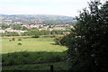
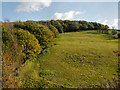
View over Hadfield
From the edge of Banks Wood.
Image: © David Lally
Taken: 6 Jun 2004
0.07 miles
2
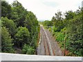
The line to Dinting
The railway from Park Road Bridge.
Image: © Gerald England
Taken: 28 Jun 2009
0.08 miles
3
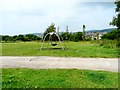
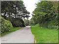
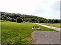
Banks Wood Park
Play equipment within Banks Wood Park.
Image: © Gerald England
Taken: 28 Jun 2009
0.08 miles
4
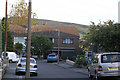
Littlebrook Close, Hadfield
Built in the late '60s most of the houses have been extended in some way. The one in the centre of the picture has been virtually doubled in size.
Image: © David Lally
Taken: 9 Jul 2004
0.09 miles
8
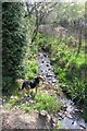
A "little brook"
This is the brook between Littlebrook Close and the Hadfield site of Glossopdale Community College. Taken in my old back garden.
This humble stream runs for about a mile, it rises in Banks Wood Park then gets above itself by giving rise to many street names:
Littlebrook Close
Brookside Close
Burnside - (built in the nineties, by a Scottish developer?)
Southbrook Close
North Brook Road.
it then disappears underground, presumably to join the Etherow before that gets to Woolley Bridge.
Image: © David Lally
Taken: 1 May 2004
0.12 miles
10

Padfield Main Road (to Tintwistle) looking towards Hadfield
A misty September evening.
The church is St.Andrew's in Hadfield: see Image
Image: © Chris
Taken: 11 Sep 2014
0.13 miles