IMAGES TAKEN NEAR TO
Lodge Bank, GLOSSOP, SK13 1QJ
Introduction
This page details the photographs taken nearby to Lodge Bank, SK13 1QJ by members of the Geograph project.
The Geograph project started in 2005 with the aim of publishing, organising and preserving representative images for every square kilometre of Great Britain, Ireland and the Isle of Man.

There are currently over 7.5m images from over14,400 individuals and you can help contribute to the project by visiting https://www.geograph.org.uk
Image Map
Images are licensed for reuse under creativecommons.org/licenses/by-sa/2.0
Notes
- Clicking on the map will re-center to the selected point.
- The higher the marker number, the further away the image location is from the centre of the postcode.
Image Listing (39 Images Found)
Images are licensed for reuse under creativecommons.org/licenses/by-sa/2.0
Image
Details
Distance
1
The childhood home of Dame Hilary Mantel
Born Hilary Thompson in 1952, the esteemed writer of historical fiction spent the first eleven years of her life at Number 20 Brosscroft, Hadfield near Glossop.
Image: © Neil Theasby
Taken: 24 Aug 2020
0.09 miles
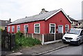
2
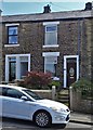
Bankbottom, Hadfield
The road is typical of the older ones in this area. The stone of the buildings is considerably less black than in the 1960's, when there were many working mills here. The road name is often spelt Bank Bottom, but on the road signs it appears as Bankbottom.
Image: © P L Chadwick
Taken: 7 May 2011
0.14 miles
3
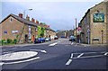
Waterside
The junction of Waterside and Goddard Lane.
Image: © David Dixon
Taken: 5 Nov 2012
0.15 miles
4
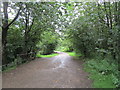
Footpath near Tintwistle Bridge
Part of several waymarked routes.
Image: © Jonathan Thacker
Taken: 27 Jul 2020
0.15 miles
5
Hadfield Spiritualist Church, 7 Jones Street, Hadfield
This hut, which appears to be made of corrugated iron, is the Hadfield Spiritualist Church. The sign outside actually says Hadfield Spiritual Church, but maybe that was a mistake, or the name has changed. The church is a member of the Spiritualists' National Union.
Image: © P L Chadwick
Taken: 7 May 2011
0.15 miles
6
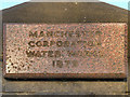
Waterworks Plaque
Plaque on Image
MANCHESTER
CORPORATION
WATER WORKS
1879
Image: © David Dixon
Taken: 5 Nov 2012
0.15 miles
7
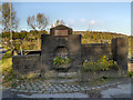
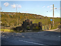
Waterworks Wall, Waterside
The wall of the old nineteenth century Manchester Corporation Waterworks (see Image]) at the junction of Waterside and Goddard Lane, in the valley below Bottoms Reservoir.
Image: © David Dixon
Taken: 5 Nov 2012
0.15 miles
8
The New Lamp, Hadfield
Public house at the junction of Station Road and Bankbottom.
Image: © David Dixon
Taken: 5 Nov 2012
0.16 miles
9
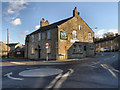
Hadfield, The New Lamp
Public house at the junction of Station Road and Bankbottom.
Image: © David Dixon
Taken: 5 Nov 2012
0.16 miles
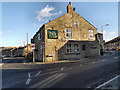
10
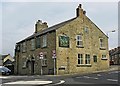
The New Lamp (1), 12 Bankbottom, Hadfield
Located on the corner of Bankbottom and Station Road. The pub has an intriguing history, as it is reported to have been a brothel, long ago. These days it is a popular pub, and to complete the atmosphere, some years ago staff reported seeing the ghost of an unknown man.
Image
Image
Image: © L S Wilson
Taken: 7 May 2011
0.16 miles