IMAGES TAKEN NEAR TO
Elm Beds Road, STOCKPORT, SK12 1TG
Introduction
This page details the photographs taken nearby to Elm Beds Road, SK12 1TG by members of the Geograph project.
The Geograph project started in 2005 with the aim of publishing, organising and preserving representative images for every square kilometre of Great Britain, Ireland and the Isle of Man.

There are currently over 7.5m images from over14,400 individuals and you can help contribute to the project by visiting https://www.geograph.org.uk
Image Map
Images are licensed for reuse under creativecommons.org/licenses/by-sa/2.0
Notes
- Clicking on the map will re-center to the selected point.
- The higher the marker number, the further away the image location is from the centre of the postcode.
Image Listing (73 Images Found)
Images are licensed for reuse under creativecommons.org/licenses/by-sa/2.0
Image
Details
Distance
1
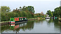
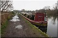
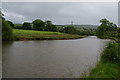
Macclesfield Canal south of Higher Poynton in Cheshire
This is the Macclesfield Canal, looking north towards Higher Poynton and Marple.
Image: © Roger Kidd
Taken: 8 Sep 2014
0.03 miles
3
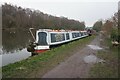
Macclesfield Canal south of Higher Poynton in Cheshire
This is the Macclesfield Canal, looking north towards Marple. Housing on the left is in Elm Beds Road.
Image: © Roger Kidd
Taken: 8 Sep 2014
0.03 miles
5
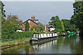
A moorland view of the Macclesfield Canal
Looking a bit bleak and windswept.
Image: © Bill Boaden
Taken: 16 Jun 2012
0.04 miles
6
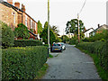
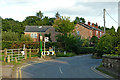
Elm Beds Road near Higher Poynton in Cheshire
This is Elm Beds Road, looking south-east from the junction with Shrigley Road.
Image: © Roger Kidd
Taken: 7 Sep 2014
0.05 miles
7
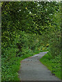
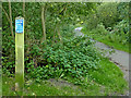
The Middlewood Way near Higher Poynton, Cheshire
This is the Middlewood Way near the Shrigley Road Bridge, looking south towards Bollington.
For much of its length, the Middlewood Way runs along an old railway track close to the Macclesfield Canal, and there are many options for easy circular walks. Here at Higher Poynton in the 1940s, up to 28 trains per day called at the station (which was demolished in 1977). https://en.wikipedia.org/wiki/Middlewood_Way
The Way follows the route of the former Macclesfield, Bollington and Marple Railway, opened in 1869 and closed in 1970. The track was lifted in early 1971. https://en.wikipedia.org/wiki/Macclesfield,_Bollington_and_Marple_Railway
Image: © Roger Kidd
Taken: 7 Sep 2014
0.08 miles
8
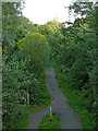
The Middlewood Way south of Higher Poynton, Cheshire
This is the Middlewood Way in a deep shady cutting, looking south towards Bollington from the Shrigley Road Bridge, with telephoto assistance.
For much of its length, the Middlewood Way runs along an old railway track close to the Macclesfield Canal, and there are many options for easy circular walks. Here at Higher Poynton in the 1940s, up to 28 trains per day called at the station (which was demolished in 1977). https://en.wikipedia.org/wiki/Middlewood_Way
The Way follows the route of the former Macclesfield, Bollington and Marple Railway, opened in 1869 and closed in 1970. The track was lifted in early 1971. https://en.wikipedia.org/wiki/Macclesfield,_Bollington_and_Marple_Railway
Image: © Roger Kidd
Taken: 7 Sep 2014
0.08 miles
9
Shrigley Road near Higher Poynton in Cheshire
This is Shrigley Road, looking east-south-east from the bridge across he Middlewood Way (dismantled railway). The housing is in Elm Beds Road.
Image: © Roger Kidd
Taken: 7 Sep 2014
0.08 miles
10
The Middlewood Way near Higher Poynton, Cheshire
This is the Middlewood Way near the Shrigley Road Bridge, looking south towards Bollington.
For much of its length, the Middlewood Way runs along an old railway track close to the Macclesfield Canal, and there are many options for easy circular walks. Here at Higher Poynton in the 1940s, up to 28 trains per day called at the station (which was demolished in 1977). https://en.wikipedia.org/wiki/Middlewood_Way
The Way follows the route of the former Macclesfield, Bollington and Marple Railway, opened in 1869 and closed in 1970. The track was lifted in early 1971. https://en.wikipedia.org/wiki/Macclesfield,_Bollington_and_Marple_Railway
Image: © Roger Kidd
Taken: 7 Sep 2014
0.09 miles