IMAGES TAKEN NEAR TO
Silk Close, STOCKPORT, SK1 1AP
Introduction
This page details the photographs taken nearby to Silk Close, SK1 1AP by members of the Geograph project.
The Geograph project started in 2005 with the aim of publishing, organising and preserving representative images for every square kilometre of Great Britain, Ireland and the Isle of Man.

There are currently over 7.5m images from over14,400 individuals and you can help contribute to the project by visiting https://www.geograph.org.uk
Image Map
Images are licensed for reuse under creativecommons.org/licenses/by-sa/2.0
Notes
- Clicking on the map will re-center to the selected point.
- The higher the marker number, the further away the image location is from the centre of the postcode.
Image Listing (324 Images Found)
Images are licensed for reuse under creativecommons.org/licenses/by-sa/2.0
Image
Details
Distance
1
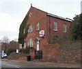
Chapel Studio
Formerly Orchard Street Congregational Church. In recent years it was converted into a film studio but is now empty office accommodation.
Image: © Gerald England
Taken: 9 Dec 2010
0.02 miles
2
Chapel Studio
Formerly Orchard Street Congregational Church. In recent years it was converted into a film studio but is now empty office accommodation.
Image: © Gerald England
Taken: 9 Dec 2010
0.02 miles
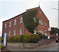
3
Churchgate House
Presently used by Stockport Samaritans.
Image: © Gerald England
Taken: 9 Dec 2010
0.02 miles
4
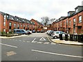
New houses on Spinner Street
Recently built houses on Spinner Street Image
Image: © Gerald England
Taken: 5 Jan 2018
0.04 miles
5
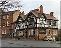
Thatched House
The building was first mentioned in 1744 as belonging to surgeon Dr.Briscall's practice, which gave free consultations and was effectively the forerunner to Stockport infirmary. The present building dates from the 19th century. Until recently the pub was a popular music venue but is currently closed.
Image
Image: © Gerald England
Taken: 9 Dec 2010
0.04 miles
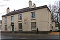
6
The Thatched House
The Thatched House on Churchgate was rebuilt in 1899, on the site of a 17th century timber-framed building of the same name. The 2-storey building is constructed of sandstone with a timber-framed first floor with decorative bracing. The roof is clay-tiled, the stacks are brick. The double gabled front elevation has a semi-elliptical arched central doorway with double timber doors, 4-light windows either side have etched glass inscribed with the name of the pub and Stowells Ales. The first floor has two 3-light oriel windows with a small oriel over the door, the gables have carved barge boards with finials. The right return to Lavender Brow is similar. There are red brick outshuts to the rear.
The earlier timber-framed building was known as The Thatched House, and was an inn or tavern from the late 18th century. In the early 21st century the pub was renowned as a music venue but has been closed since 2009.
Image: © Gerald England
Taken: 7 Sep 2013
0.04 miles
7
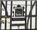
Fine Ales
So says the sign on the former Thatched House Image
Image: © Gerald England
Taken: 7 Sep 2013
0.04 miles
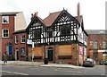
8
The former Thatched House
The building was first mentioned in 1744 as belonging to surgeon Dr.Briscall's practice, which gave free consultations and was effectively the forerunner to Stockport infirmary. The present building dates from the 19th century. In the early 21st century the pub was renowned as a music venue but closed in 2009.
Image: © Gerald England
Taken: 5 Jan 2018
0.04 miles
9
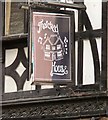
Sign of The Thatched House
The sign for the Thatched House Image
Image: © Gerald England
Taken: 9 Dec 2010
0.04 miles
10
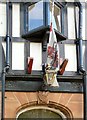
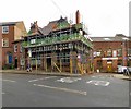
Furled flag on the former Thatched House
A furled flag and a lamp above the 1899 date-stone are the only remaining remnants on the outside of the Thatched House Image that has been closed since 2009.
Image: © Gerald England
Taken: 26 Apr 2014
0.04 miles