IMAGES TAKEN NEAR TO
Catchpenny Lane, MACCLESFIELD, SK11 9DG
Introduction
This page details the photographs taken nearby to Catchpenny Lane, SK11 9DG by members of the Geograph project.
The Geograph project started in 2005 with the aim of publishing, organising and preserving representative images for every square kilometre of Great Britain, Ireland and the Isle of Man.

There are currently over 7.5m images from over14,400 individuals and you can help contribute to the project by visiting https://www.geograph.org.uk
Image Map
Images are licensed for reuse under creativecommons.org/licenses/by-sa/2.0
Notes
- Clicking on the map will re-center to the selected point.
- The higher the marker number, the further away the image location is from the centre of the postcode.
Image Listing (2 Images Found)
Images are licensed for reuse under creativecommons.org/licenses/by-sa/2.0
Image
Details
Distance
1
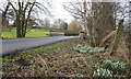
Dinglebrook Bridge, Catchpenny Lane, Lower Withington
Image: © Peter Turner
Taken: 22 Feb 2012
0.08 miles
2
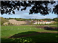
Towards the sand pit at Withington
A view across the fields west of Catchpenny Pool to the sand workings near Dairy House Farm
Image: © Richard Law
Taken: 17 Sep 2010
0.21 miles