IMAGES TAKEN NEAR TO
Townley Street, MACCLESFIELD, SK11 6HY
Introduction
This page details the photographs taken nearby to Townley Street, SK11 6HY by members of the Geograph project.
The Geograph project started in 2005 with the aim of publishing, organising and preserving representative images for every square kilometre of Great Britain, Ireland and the Isle of Man.

There are currently over 7.5m images from over14,400 individuals and you can help contribute to the project by visiting https://www.geograph.org.uk
Image Map
Images are licensed for reuse under creativecommons.org/licenses/by-sa/2.0
Notes
- Clicking on the map will re-center to the selected point.
- The higher the marker number, the further away the image location is from the centre of the postcode.
Image Listing (192 Images Found)
Images are licensed for reuse under creativecommons.org/licenses/by-sa/2.0
Image
Details
Distance
1
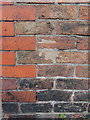
Infilled bench mark in Townley Street, Macclesfield
This Ordnance Survey bench mark was recorded on old-maps between 1909 and 1968, but is no longer on the O.S. database. It is at the corner of Townley Street with Charlotte Street and has now been infilled with mortar. See also Image
Image: © John S Turner
Taken: 21 Jun 2013
0.01 miles
5
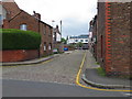
Charlotte Street at its junction with Townley Street
Looking north along Charlotte Street from its junction with Townley Street. There is an infilled Ordnance Survey bench mark on the Townley Street wall on the right - Image
Image: © John S Turner
Taken: 21 Jun 2013
0.03 miles
6
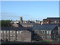
Part of the lower town seen from Green Street
The church is the one that appears in Image In the foreground are mills which have been converted to iffoces.
Image: © Alan Murray-Rust
Taken: 16 Sep 2007
0.03 miles
7
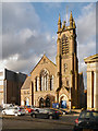
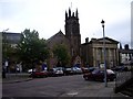
Macclesfield URC, Park Green
The United Reformed Church on Park Green was built in 1877. It was originally a Congregational church and replaced an older chapel built in 1788 located nearby.
The church is a Grade II listed building (http://list.english-heritage.org.uk/resultsingle.aspx?uid=1206940 National Heritage List for England).
Image: © David Dixon
Taken: 3 Oct 2012
0.03 miles
8
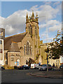
Macclesfield United Reformed Church
The United Reformed Church on Park Green was built in 1877. It was originally a Congregational church and replaced an older chapel built in 1788 located nearby.
The church is a Grade II listed building (http://list.english-heritage.org.uk/resultsingle.aspx?uid=1206940 National Heritage List for England).
Image: © David Dixon
Taken: 3 Oct 2012
0.04 miles