IMAGES TAKEN NEAR TO
Rainow, MACCLESFIELD, SK10 5UX
Introduction
This page details the photographs taken nearby to SK10 5UX by members of the Geograph project.
The Geograph project started in 2005 with the aim of publishing, organising and preserving representative images for every square kilometre of Great Britain, Ireland and the Isle of Man.

There are currently over 7.5m images from over14,400 individuals and you can help contribute to the project by visiting https://www.geograph.org.uk
Image Map
Images are licensed for reuse under creativecommons.org/licenses/by-sa/2.0
Notes
- Clicking on the map will re-center to the selected point.
- The higher the marker number, the further away the image location is from the centre of the postcode.
Image Listing (8 Images Found)
Images are licensed for reuse under creativecommons.org/licenses/by-sa/2.0
Image
Details
Distance
1
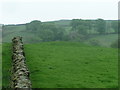
Bowl barrow, Ginclough
Looking southwest from the footpath. See http://magic.defra.gov.uk/rsm/22568.pdf for more information. The farm in the background is Slack-o'th'-Moor.
Image: © Dave Dunford
Taken: 14 May 2006
0.11 miles
2
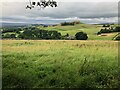
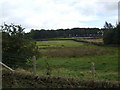
View down to Ginclough
The collection of houses in the centre of the picture is the hamlet of Ginclough. The prominent hill in the background is Big Low.
Image: © Philip Cornwall
Taken: 15 Aug 2021
0.12 miles
6
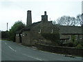
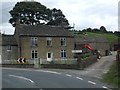
The Mill, Ginclough
Attractive stone millhouse beside B5470 at Ginclough.
Image: © Dave Dunford
Taken: 14 May 2006
0.19 miles
7
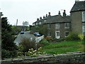
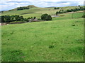
Ginclough
The B5470 passes through this attractive stone-built hamlet.
Image: © Dave Dunford
Taken: 14 May 2006
0.19 miles
8
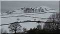
Snowy view towards Big Low from above Ginclough, Rainow
Image: © Colin Park
Taken: 5 Mar 2016
0.25 miles