IMAGES TAKEN NEAR TO
Dumbah Lane, MACCLESFIELD, SK10 4EW
Introduction
This page details the photographs taken nearby to Dumbah Lane, SK10 4EW by members of the Geograph project.
The Geograph project started in 2005 with the aim of publishing, organising and preserving representative images for every square kilometre of Great Britain, Ireland and the Isle of Man.

There are currently over 7.5m images from over14,400 individuals and you can help contribute to the project by visiting https://www.geograph.org.uk
Image Map
Images are licensed for reuse under creativecommons.org/licenses/by-sa/2.0
Notes
- Clicking on the map will re-center to the selected point.
- The higher the marker number, the further away the image location is from the centre of the postcode.
Image Listing (8 Images Found)
Images are licensed for reuse under creativecommons.org/licenses/by-sa/2.0
Image
Details
Distance
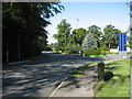
2
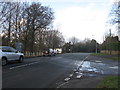
Dumbah Lane/Heybridge Lane/Manchester Road junction
Dumbah Lane comes in from the right foreground. The major road is the A538 Manchester Road from the left. The A538 becomes Heybridge Lane as it bears left before the white house visible left of centre. The ongoing 'major' road, once the A523 to Stockport, thereafter becomes the B5091 and is named London Road.
Image: © Peter Turner
Taken: 26 Jan 2012
0.09 miles

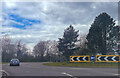
8
Tytherington business park traffic island
With the building of the bypass nearby this new traffic island was built to accommodate the increase in traffic to the new business park
Image: © Paul Anderson
Taken: 26 Sep 2006
0.23 miles