IMAGES TAKEN NEAR TO
Cumberland Street, MACCLESFIELD, SK10 1DD
Introduction
This page details the photographs taken nearby to Cumberland Street, SK10 1DD by members of the Geograph project.
The Geograph project started in 2005 with the aim of publishing, organising and preserving representative images for every square kilometre of Great Britain, Ireland and the Isle of Man.

There are currently over 7.5m images from over14,400 individuals and you can help contribute to the project by visiting https://www.geograph.org.uk
Image Map
Images are licensed for reuse under creativecommons.org/licenses/by-sa/2.0
Notes
- Clicking on the map will re-center to the selected point.
- The higher the marker number, the further away the image location is from the centre of the postcode.
Image Listing (188 Images Found)
Images are licensed for reuse under creativecommons.org/licenses/by-sa/2.0
Image
Details
Distance
1
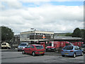
Royal Mail Delivery Office, Macclesfield
Reached from the east side of Jordangate; postbox number SK10 166.
Image: © Robin Stott
Taken: 25 Sep 2010
0.03 miles
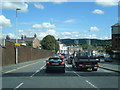
2
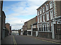
Jordangate, Macclesfield
Looking north towards the junction with the section of the dual carriageway called Hibel Road. The modern building on the left is the Jordangate multistorey car park.
Image: © Robin Stott
Taken: 25 Sep 2010
0.03 miles
3
Extension to 19 King Edward Street
Built in 1927 when No.19 http://www.geograph.org.uk/photo/5667389 was converted to office use. Listed Grade II as part of the main building.
Image: © Alan Murray-Rust
Taken: 25 Jan 2018
0.05 miles
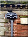
4
19 King Edward Street ? detail
Rainwater head dated 1758. See http://www.geograph.org.uk/photo/5667389 for location, also http://www.geograph.org.uk/photo/5667367 .
Image: © Alan Murray-Rust
Taken: 25 Jan 2018
0.06 miles
5
Extension to 19 King Edward Street ? detail
See http://www.geograph.org.uk/photo/5667361 for location. The date is that of the construction of the extension.
Image: © Alan Murray-Rust
Taken: 25 Jan 2018
0.06 miles
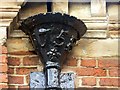
6
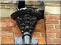
19 King Edward Street ? detail
Rainwater head with the initials of Francis Beswick for whom the house was built. See http://www.geograph.org.uk/photo/5667389 for location, also http://www.geograph.org.uk/photo/5667368 .
Image: © Alan Murray-Rust
Taken: 25 Jan 2018
0.06 miles
8
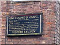
Sign to King Edward Street Chapel, corner of Jordangate
Not quite as old as the chapel itself http://www.geograph.org.uk/photo/5667358 . Although it proclaims 'Visitors welcome', the chapel was closed at the time of my visit.
Image: © Alan Murray-Rust
Taken: 25 Jan 2018
0.06 miles
9
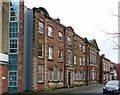
19 King Edward Street
A large house built in 1758 for Francis Beswick, a silk manufacturer and later Mayor of Macclesfield. The original house comprises the 5 bays centred on the main door. The end bays with segmental pediments are part of the 1927 extension http://www.geograph.org.uk/photo/5667361 when the building was converted to offices. The whole is Listed Grade II.
Image: © Alan Murray-Rust
Taken: 25 Jan 2018
0.06 miles
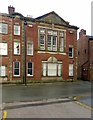
10
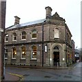
Macclesfield Library
The former District Bank building, built around 1900 as the Manchester and Liverpool District Banking Company Ltd. Listed Grade II.
Image: © Alan Murray-Rust
Taken: 25 Jan 2018
0.07 miles