IMAGES TAKEN NEAR TO
Hensby Avenue, BUNTINGFORD, SG9 9RG
Introduction
This page details the photographs taken nearby to Hensby Avenue, SG9 9RG by members of the Geograph project.
The Geograph project started in 2005 with the aim of publishing, organising and preserving representative images for every square kilometre of Great Britain, Ireland and the Isle of Man.

There are currently over 7.5m images from over14,400 individuals and you can help contribute to the project by visiting https://www.geograph.org.uk
Image Map
Images are licensed for reuse under creativecommons.org/licenses/by-sa/2.0
Notes
- Clicking on the map will re-center to the selected point.
- The higher the marker number, the further away the image location is from the centre of the postcode.
Image Listing (17 Images Found)
Images are licensed for reuse under creativecommons.org/licenses/by-sa/2.0
Image
Details
Distance
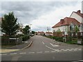
1
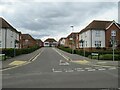
Hensby Avenue, Buntingford
Hensby Avenue forms part of a modern housing development on the outskirts of Buntingford, in north Hertfordshire.
Image: © Malc McDonald
Taken: 25 Sep 2022
0.05 miles
2
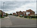
Neale Drive, Buntingford
Neale Drive forms part of a modern housing development on the outskirts of Buntingford, in north Hertfordshire.
Image: © Malc McDonald
Taken: 25 Sep 2022
0.08 miles
3
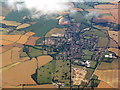
Buntingford from the air
Looking south along Ermine Street and the bypass [A10].
Image: © M J Richardson
Taken: 12 Jul 2017
0.10 miles
4
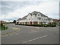
Apartment block on Norris Way, Buntingford
A modern apartment block on the corner of Norris Way and Ermine Street on the outskirts of Buntingford. The housing development and Norris Way itself are recent, Ermine Street is much older.
Image: © Malc McDonald
Taken: 25 Sep 2022
0.13 miles
6
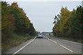
Ermine Street, Buntingford
This was the original main road now bypassed by a dual carriageway
Image: © David Howard
Taken: 28 Oct 2017
0.17 miles
9
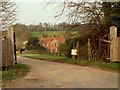
A view of Corney Bury Farm from Ermine Street
Image: © Robert Edwards
Taken: 6 Apr 2009
0.19 miles
10
Seymour Road, Buntingford
Seymour Road is a private road in a modern housing development on the outskirts of Buntingford, in north Hertfordshire.
Image: © Malc McDonald
Taken: 25 Sep 2022
0.19 miles