IMAGES TAKEN NEAR TO
Cottered, BUNTINGFORD, SG9 9PT
Introduction
This page details the photographs taken nearby to SG9 9PT by members of the Geograph project.
The Geograph project started in 2005 with the aim of publishing, organising and preserving representative images for every square kilometre of Great Britain, Ireland and the Isle of Man.

There are currently over 7.5m images from over14,400 individuals and you can help contribute to the project by visiting https://www.geograph.org.uk
Image Map
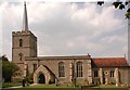
Images are licensed for reuse under creativecommons.org/licenses/by-sa/2.0
Notes
- Clicking on the map will re-center to the selected point.
- The higher the marker number, the further away the image location is from the centre of the postcode.
Image Listing (35 Images Found)
Images are licensed for reuse under creativecommons.org/licenses/by-sa/2.0
Image
Details
Distance
2
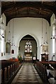
St John the Baptist, Cottered, Herts - East end
Image: © John Salmon
Taken: 16 Jun 2003
0.04 miles
3
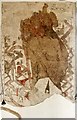
St John the Baptist, Cottered, Herts - Wall Painting
Image: © John Salmon
Taken: 16 Jun 2003
0.04 miles
4
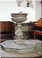
St John the Baptist, Cottered, Herts - Font
Image: © John Salmon
Taken: 16 Jun 2003
0.04 miles
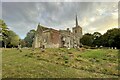
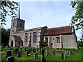
7
Church of St John the Baptist, Cottered
With the typical 'Hertfordshire spike'.
Image: © Stefan Czapski
Taken: 30 Jun 2013
0.05 miles
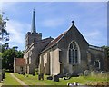
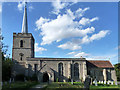
9
St John the Baptist, Cottered
The nave, chancel with its south porch and tower were all built around 1350. The north chapel was added in C15. The roof of the nave and most of the windows also date from this period.
Image: © Bikeboy
Taken: 17 May 2015
0.05 miles
10
Cottered church
St. John the Baptist's.
Image: © Robin Webster
Taken: 21 Aug 2015
0.05 miles