IMAGES TAKEN NEAR TO
Cherry Green Lane, BUNTINGFORD, SG9 9LD
Introduction
This page details the photographs taken nearby to Cherry Green Lane, SG9 9LD by members of the Geograph project.
The Geograph project started in 2005 with the aim of publishing, organising and preserving representative images for every square kilometre of Great Britain, Ireland and the Isle of Man.

There are currently over 7.5m images from over14,400 individuals and you can help contribute to the project by visiting https://www.geograph.org.uk
Image Map
Images are licensed for reuse under creativecommons.org/licenses/by-sa/2.0
Notes
- Clicking on the map will re-center to the selected point.
- The higher the marker number, the further away the image location is from the centre of the postcode.
Image Listing (3 Images Found)
Images are licensed for reuse under creativecommons.org/licenses/by-sa/2.0
Image
Details
Distance
2
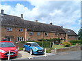
Post-war housing, Westmill
This group of houses bear the lettering "Town End 1947" in a typically confident and optimistic Atlee era sort of way.
Image: © Bikeboy
Taken: 21 Jun 2015
0.18 miles
3
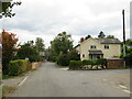
Westmill, near Buntingford
Westmill is a small village in the north Hertfordshire countryside.
Image: © Malc McDonald
Taken: 25 Sep 2022
0.25 miles