IMAGES TAKEN NEAR TO
Reed Close, BUNTINGFORD, SG9 9GU
Introduction
This page details the photographs taken nearby to Reed Close, SG9 9GU by members of the Geograph project.
The Geograph project started in 2005 with the aim of publishing, organising and preserving representative images for every square kilometre of Great Britain, Ireland and the Isle of Man.

There are currently over 7.5m images from over14,400 individuals and you can help contribute to the project by visiting https://www.geograph.org.uk
Image Map
Images are licensed for reuse under creativecommons.org/licenses/by-sa/2.0
Notes
- Clicking on the map will re-center to the selected point.
- The higher the marker number, the further away the image location is from the centre of the postcode.
Image Listing (5 Images Found)
Images are licensed for reuse under creativecommons.org/licenses/by-sa/2.0
Image
Details
Distance
1
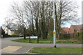
Stearn Way at the junction of London Road
Image: © David Howard
Taken: 3 Apr 2022
0.17 miles
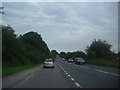
2

A10 heading north
The Roman Ermine Street. This carries on straight through Buntingford, the modern road bypasses the town.
Image: © Robin Webster
Taken: 12 Feb 2018
0.20 miles
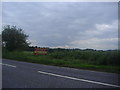
3

Approaching the end of the Buntingford bypass
Image: © N Chadwick
Taken: 18 Oct 2015
0.21 miles
4
Layby on the A10, Buntingford
This is a straight road as it's Roman, Ermine Street.
Image: © David Howard
Taken: 13 Jun 2012
0.24 miles