IMAGES TAKEN NEAR TO
Meetinghouse Lane, BUNTINGFORD, SG9 9FF
Introduction
This page details the photographs taken nearby to Meetinghouse Lane, SG9 9FF by members of the Geograph project.
The Geograph project started in 2005 with the aim of publishing, organising and preserving representative images for every square kilometre of Great Britain, Ireland and the Isle of Man.

There are currently over 7.5m images from over14,400 individuals and you can help contribute to the project by visiting https://www.geograph.org.uk
Image Map
Images are licensed for reuse under creativecommons.org/licenses/by-sa/2.0
Notes
- Clicking on the map will re-center to the selected point.
- The higher the marker number, the further away the image location is from the centre of the postcode.
Image Listing (74 Images Found)
Images are licensed for reuse under creativecommons.org/licenses/by-sa/2.0
Image
Details
Distance
1
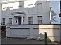
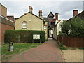
Georgian house on High Street, Buntingford
I don't know what's happened to the upstairs windows but they were normal a year earlier.
Image: © David Howard
Taken: 28 Oct 2017
0.01 miles
3
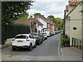
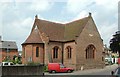
Church Street, Buntingford
Church Street in the market town of Buntingford, in north Hertfordshire. The road is a one-way street.
Image: © Malc McDonald
Taken: 25 Sep 2022
0.03 miles
5
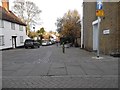
Passageway in Buntingford
A passageway leading from a car park into Buntingford's High Street.
Image: © Malc McDonald
Taken: 25 Sep 2022
0.03 miles
6
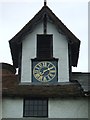
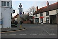
Town Clock
The clock dates from the mid 17th century and is positioned in a turret between two buildings. As was the norm for the time there is only one hand and a bell is struck for the hours.
Image: © John M
Taken: 12 May 2013
0.04 miles
8
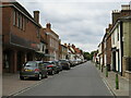
Buntingford High Street
The high street in Buntingford, a market town in north Hertfordshire. This road lies on the route of Ermine Street, a Roman road. It formed part of the route of the A10 trunk road, until a by-pass was built to divert through traffic away from the town centre.
Image: © Malc McDonald
Taken: 25 Sep 2022
0.04 miles