IMAGES TAKEN NEAR TO
High Street, BUNTINGFORD, SG9 9AB
Introduction
This page details the photographs taken nearby to High Street, SG9 9AB by members of the Geograph project.
The Geograph project started in 2005 with the aim of publishing, organising and preserving representative images for every square kilometre of Great Britain, Ireland and the Isle of Man.

There are currently over 7.5m images from over14,400 individuals and you can help contribute to the project by visiting https://www.geograph.org.uk
Image Map
Images are licensed for reuse under creativecommons.org/licenses/by-sa/2.0
Notes
- Clicking on the map will re-center to the selected point.
- The higher the marker number, the further away the image location is from the centre of the postcode.
Image Listing (73 Images Found)
Images are licensed for reuse under creativecommons.org/licenses/by-sa/2.0
Image
Details
Distance

3
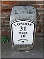
Old Milepost
Old milepost on what was the A.10 at Buntingford, Hertfordshire for overall view see http://www.geograph.org.uk/photo/1790331
Image: © Keith Evans
Taken: 6 Apr 2010
0.02 miles
4
War Memorial, Buntingford
The war memorial stands near the market hall. The building on the left is St Peter's church, which is reputed to be the earliest entirely brick-built church in the county of Hertfordshire. It was originally built in 1615.
Image: © Eirian Evans
Taken: 8 Apr 2009
0.02 miles
5
Old Milepost
Old milepost on what was the A.10 at Buntingford, Hertfordshire for close up view see http://www.geograph.org.uk/photo/1790347
Image: © Keith Evans
Taken: 6 Apr 2010
0.02 miles
6
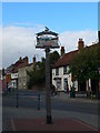
Buntingford Village Sign
Bunting on the top and showing the flags of France and Spain, as the town is twinned with Luynes in France and Olvega in Spain.
Image: © Eirian Evans
Taken: 10 Sep 2009
0.03 miles
7
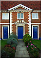
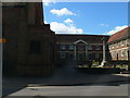
Pedimented centrepiece, almshouses, Buntingford
17th century almshouses, Buntingford: Grade II listed http://www.britishlistedbuildings.co.uk/en-159780-the-almhouses-1-15-buntingford
Image: © Jim Osley
Taken: 15 Oct 2011
0.03 miles
9
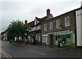
Historic buildings, Buntingford High Street
Image: © Jim Osley
Taken: 15 Oct 2011
0.03 miles
10
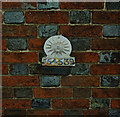
Sun Fire Insurance mark, Buntingford
For a comprehensive history of British fire insurance marks follow this http://www.firemarks.co.uk/home.htm.
Image: © Jim Osley
Taken: 15 Oct 2011
0.03 miles