IMAGES TAKEN NEAR TO
Sandon Lane, BUNTINGFORD, SG9 0RX
Introduction
This page details the photographs taken nearby to Sandon Lane, SG9 0RX by members of the Geograph project.
The Geograph project started in 2005 with the aim of publishing, organising and preserving representative images for every square kilometre of Great Britain, Ireland and the Isle of Man.

There are currently over 7.5m images from over14,400 individuals and you can help contribute to the project by visiting https://www.geograph.org.uk
Image Map
Images are licensed for reuse under creativecommons.org/licenses/by-sa/2.0
Notes
- Clicking on the map will re-center to the selected point.
- The higher the marker number, the further away the image location is from the centre of the postcode.
Image Listing (5 Images Found)
Images are licensed for reuse under creativecommons.org/licenses/by-sa/2.0
Image
Details
Distance
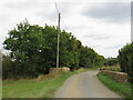
2
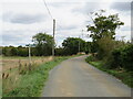
Throcking Lane, near Buntingford
Throcking Lane is a minor lane through countryside in north Hertfordshire.
The signpost to the left indicates that a public footpath crosses the road.
Image: © Malc McDonald
Taken: 25 Sep 2022
0.19 miles
3
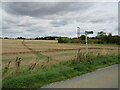
Public footpath near Buntingford
A public footpath across a field in the countryside of north Hertfordshire.
Image: © Malc McDonald
Taken: 25 Sep 2022
0.20 miles
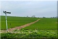
5
Throcking Lane near Buntingford
Throcking Lane is a minor lane through north Hertfordshire countryside.
Image: © Malc McDonald
Taken: 25 Sep 2022
0.22 miles