IMAGES TAKEN NEAR TO
Roe Green, BUNTINGFORD, SG9 0QE
Introduction
This page details the photographs taken nearby to Roe Green, SG9 0QE by members of the Geograph project.
The Geograph project started in 2005 with the aim of publishing, organising and preserving representative images for every square kilometre of Great Britain, Ireland and the Isle of Man.

There are currently over 7.5m images from over14,400 individuals and you can help contribute to the project by visiting https://www.geograph.org.uk
Image Map
Images are licensed for reuse under creativecommons.org/licenses/by-sa/2.0
Notes
- Clicking on the map will re-center to the selected point.
- The higher the marker number, the further away the image location is from the centre of the postcode.
Image Listing (21 Images Found)
Images are licensed for reuse under creativecommons.org/licenses/by-sa/2.0
Image
Details
Distance

5
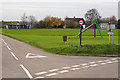
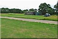
Roe Green Village
This is the Village of Roe Green where the housing is set back 100 mtrs or so from the roads serving the village. The village Cricket Green is seen along with the Pavilion. This is a typical layout for villages in this part of Hertfordshire and nearby Essex.
Image: © Richard Thomas
Taken: 22 Nov 2006
0.13 miles
10
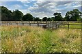
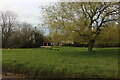
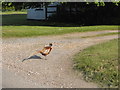
Path into Roe Green by the equine excersise yard
Image: © Philip Jeffrey
Taken: 9 Jul 2023
0.16 miles