IMAGES TAKEN NEAR TO
Cumberlow Green, BUNTINGFORD, SG9 0QD
Introduction
This page details the photographs taken nearby to Cumberlow Green, SG9 0QD by members of the Geograph project.
The Geograph project started in 2005 with the aim of publishing, organising and preserving representative images for every square kilometre of Great Britain, Ireland and the Isle of Man.

There are currently over 7.5m images from over14,400 individuals and you can help contribute to the project by visiting https://www.geograph.org.uk
Image Map
Images are licensed for reuse under creativecommons.org/licenses/by-sa/2.0
Notes
- Clicking on the map will re-center to the selected point.
- The higher the marker number, the further away the image location is from the centre of the postcode.
Image Listing (9 Images Found)
Images are licensed for reuse under creativecommons.org/licenses/by-sa/2.0
Image
Details
Distance
1
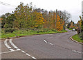
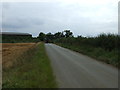
A507 at Cumberlow Green
Looking North, the A507 winds through Cumberlow Green towards Baldock. The road to the left leads to Cromer. Just out of sight is another junction where a left turn is required to follow the A507. Many an unsuspecting driver has been caught by this where the minor road takes priority.
Image: © Richard Thomas
Taken: 22 Nov 2006
0.05 miles
9
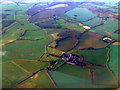
Cumberlow Green Farm from the air
Viewed from a Luton bound flight from Prague.
Image: © Thomas Nugent
Taken: 18 Nov 2011
0.21 miles