IMAGES TAKEN NEAR TO
Bury Weir Lane, BUNTINGFORD, SG9 0PU
Introduction
This page details the photographs taken nearby to Bury Weir Lane, SG9 0PU by members of the Geograph project.
The Geograph project started in 2005 with the aim of publishing, organising and preserving representative images for every square kilometre of Great Britain, Ireland and the Isle of Man.

There are currently over 7.5m images from over14,400 individuals and you can help contribute to the project by visiting https://www.geograph.org.uk
Image Map
Images are licensed for reuse under creativecommons.org/licenses/by-sa/2.0
Notes
- Clicking on the map will re-center to the selected point.
- The higher the marker number, the further away the image location is from the centre of the postcode.
Image Listing (23 Images Found)
Images are licensed for reuse under creativecommons.org/licenses/by-sa/2.0
Image
Details
Distance
1
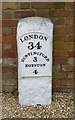
Old Milestone by Buckland Bury, Buckland parish
Metal plate attached to stone post by the A10, in parish of Buckland (East Hertfordshire District), Buckland Bury, in yard of farm house; Formerly on High Road in Buckland village; erected in present position c.1970. Wadesmill plate, erected by the Wadesmill turnpike trust in the 19th century.
N.B. Re-located to GR: TL 35588 33596 alongside the A10 in 2017
Inscription reads:-
LONDON
34
BUNTINGFORD
3
ROYSTON
4
Grade II listed.
List Entry Number: 1308093 https://historicengland.org.uk/listing/the-list/list-entry/1308093
Milestone Society National ID: HE_LK34
Image: © MW Hallett
Taken: 18 Aug 2002
0.08 miles
2
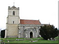
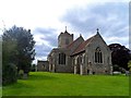
St. Andrew's Church - Buckland, Hertfordshire
This church was built by Nicholas de Bokeland in 1348. The exact date is known because he left a note of this on the glass of one of the chancel windows. Although Nicholas's glass has now gone, some fragments of 14th century glass remain in other windows. St. Andrew's is no longer used for regular worship and is now cared for by The Churches Conservation Trust.
Image: © Catherine Edwards
Taken: 27 Feb 2006
0.08 miles
3
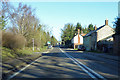
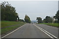
A10 heading north
Passing through Buckland.
Image: © Robin Webster
Taken: 12 Feb 2018
0.10 miles
4
St Andrew's Church, Buckland
Taken from a couple of kilometres away.
Image: © Bikeboy
Taken: 4 May 2013
0.12 miles
5
St Andrew's church, Buckland
The church is believed to have been built in C14 as it is recorded in a history of 1725 that glass in a window of the chancel bore the inscription “Nicholai de Bakeland qui istanc Ecclesiam cum Capella Beatiae Mariae construxit A o Domini 1348”. To this church a tower was added later in the century. Restoration was carried out in 1848 and 1875.
Image: © Bikeboy
Taken: 17 May 2015
0.13 miles
6
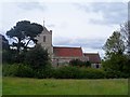
St Andrew's church Buckland
The church is believed to have been built in C14 as it is recorded in a history of 1725 that glass in a window of the chancel bore the inscription “Nicholai de Bakeland qui istanc Ecclesiam cum Capella Beatiae Mariae construxit A o Domini 1348”. To this church a tower was added later in the century. Restoration was carried out in 1848 and 1875.
Image: © Bikeboy
Taken: 17 May 2015
0.13 miles
8
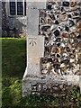
Benchmark on St Andrew Buckland
A well-defined cut mark at the east end of St Andrew's Church, Buckland. It appears it may have been reinstated on new stone. The church is no longer in regular use but is well maintained by the Churches Conservation Trust: www.visitchurches.org.uk
Image: © Mike W Hallett
Taken: 1 Feb 2022
0.13 miles
9
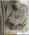
St Andrew, Buckland, Herts - Label head
Image: © John Salmon
Taken: 18 Aug 2006
0.13 miles