IMAGES TAKEN NEAR TO
Brent Pelham, BUNTINGFORD, SG9 0HJ
Introduction
This page details the photographs taken nearby to SG9 0HJ by members of the Geograph project.
The Geograph project started in 2005 with the aim of publishing, organising and preserving representative images for every square kilometre of Great Britain, Ireland and the Isle of Man.

There are currently over 7.5m images from over14,400 individuals and you can help contribute to the project by visiting https://www.geograph.org.uk
Image Map
Images are licensed for reuse under creativecommons.org/licenses/by-sa/2.0
Notes
- Clicking on the map will re-center to the selected point.
- The higher the marker number, the further away the image location is from the centre of the postcode.
Image Listing (7 Images Found)
Images are licensed for reuse under creativecommons.org/licenses/by-sa/2.0
Image
Details
Distance
1
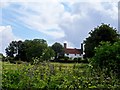
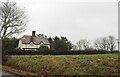
Beeches Farmhouse
Late C16 or early C17 manor house.he most important feature (according to its entry in British Listed Buildings) are the C17 chimney stacks. See http://www.britishlistedbuildings.co.uk/en-160135-beeches-farmhouse-brent-pelham-hertfords
Image: © Bikeboy
Taken: 28 Jun 2014
0.02 miles
2
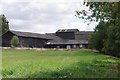
Farm Buildings at Beeches
Taken from Bridleway 029 From Washall Green to Cakebreads Lane where it becomes Essex Bridleway PROW 10_30.
Image: © Glyn Baker
Taken: 2 Aug 2020
0.04 miles
4
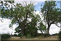
Bridleway 29 and Signs of Ash Dieback?
Taken at the junction with footpath 021 I am worried the Ashes are showing signs of Calara due to the number of dead branches.
Image: © Glyn Baker
Taken: 2 Aug 2020
0.16 miles
6
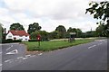
Washall Green and Arnold's Seat
A Motorbike speeds past Washall Green House. The seat is dedicated to one Arnold Hitchcock 1934 - 2017
Image: © Glyn Baker
Taken: 2 Aug 2020
0.25 miles
7
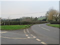
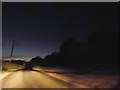
Road junction at Washall Green, near Brent Pelham
A road junction at Washall Green, in north Hertfordshire countryside. The road bending to the right is the B1038.
Image: © Malc McDonald
Taken: 25 Jan 2020
0.25 miles