IMAGES TAKEN NEAR TO
Hare Street Road, BUNTINGFORD, SG9 0FB
Introduction
This page details the photographs taken nearby to Hare Street Road, SG9 0FB by members of the Geograph project.
The Geograph project started in 2005 with the aim of publishing, organising and preserving representative images for every square kilometre of Great Britain, Ireland and the Isle of Man.

There are currently over 7.5m images from over14,400 individuals and you can help contribute to the project by visiting https://www.geograph.org.uk
Image Map
Images are licensed for reuse under creativecommons.org/licenses/by-sa/2.0
Notes
- Clicking on the map will re-center to the selected point.
- The higher the marker number, the further away the image location is from the centre of the postcode.
Image Listing (3 Images Found)
Images are licensed for reuse under creativecommons.org/licenses/by-sa/2.0
Image
Details
Distance
3

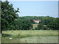
Buntingford: B1038 Hare Street Road
Taken looking in the direction of Hare Street, the boundary between the Civil Parishes of Buntingford and Hormead is around the two far trees. The trees are amongst a select group that merit individual mention on the Ordnance Survey 1:25,000 scale mapping, in this case annotated "Ash".
Image: © Nigel Cox
Taken: 19 Jun 2011
0.21 miles