IMAGES TAKEN NEAR TO
Anstey, BUNTINGFORD, SG9 0DF
Introduction
This page details the photographs taken nearby to SG9 0DF by members of the Geograph project.
The Geograph project started in 2005 with the aim of publishing, organising and preserving representative images for every square kilometre of Great Britain, Ireland and the Isle of Man.

There are currently over 7.5m images from over14,400 individuals and you can help contribute to the project by visiting https://www.geograph.org.uk
Image Map
Images are licensed for reuse under creativecommons.org/licenses/by-sa/2.0
Notes
- Clicking on the map will re-center to the selected point.
- The higher the marker number, the further away the image location is from the centre of the postcode.
Image Listing (5 Images Found)
Images are licensed for reuse under creativecommons.org/licenses/by-sa/2.0
Image
Details
Distance
1
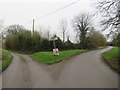
Country lanes near Anstey
A junction of minor lanes in the north Hertfordshire countryside, near the village of Anstey.
Image: © Malc McDonald
Taken: 25 Jan 2020
0.01 miles
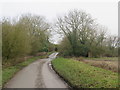
2

Country lane near Anstey
A minor lane through countryside in north Hertfordshire, near the village of Anstey.
Image: © Malc McDonald
Taken: 25 Jan 2020
0.08 miles
3
Country lane near Anstey
A minor lane through north Hertfordshire countryside, near the village of Anstey.
This image was taken on a dull January afternoon. Trees were bare for the winter season.
Image: © Malc McDonald
Taken: 25 Jan 2020
0.12 miles
4
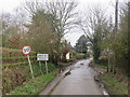
Lane into Anstey
A minor lane heading into the village of Anstey, in north Hertfordshire. The speed limit changes to 30 miles per hour here.
Image: © Malc McDonald
Taken: 25 Jan 2020
0.22 miles
5
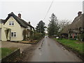
Lane in Anstey
A minor lane passing thatched houses in the small village of Anstey, in north Hertfordshire.
Image: © Malc McDonald
Taken: 25 Jan 2020
0.25 miles