IMAGES TAKEN NEAR TO
Meesden, BUNTINGFORD, SG9 0BH
Introduction
This page details the photographs taken nearby to SG9 0BH by members of the Geograph project.
The Geograph project started in 2005 with the aim of publishing, organising and preserving representative images for every square kilometre of Great Britain, Ireland and the Isle of Man.

There are currently over 7.5m images from over14,400 individuals and you can help contribute to the project by visiting https://www.geograph.org.uk
Image Map
Images are licensed for reuse under creativecommons.org/licenses/by-sa/2.0
Notes
- Clicking on the map will re-center to the selected point.
- The higher the marker number, the further away the image location is from the centre of the postcode.
Image Listing (11 Images Found)
Images are licensed for reuse under creativecommons.org/licenses/by-sa/2.0
Image
Details
Distance
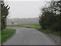
1
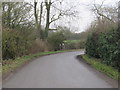
Mill Lane, near Meesden
Mill Lane is a minor road through north Hertfordshire countryside. Here it approaches a sharp pend to the right. A chevron sign warns motorists of the sharp bend.
Image: © Malc McDonald
Taken: 25 Jan 2020
0.01 miles
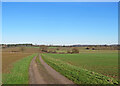
2
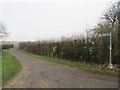
Public bridleway near Meesden
A public bridleway along a track near Meesden, in the north Hertfordshire countryside.
Image: © Malc McDonald
Taken: 25 Jan 2020
0.02 miles
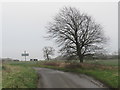
3
Mill Lane, near Meesden
Mill Lane is a minor road through north Hertfordshire countryside.
Image: © Malc McDonald
Taken: 25 Jan 2020
0.02 miles
4
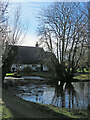
Meesden Lower Green: a frozen pond
The 17th- or 18th-century timber-framed thatched house, glimpsed against the light from Mill Lane on a cold January morning, is Grade II listed.
Image: © John Sutton
Taken: 17 Jan 2023
0.06 miles
5

Pond at Meesden Lower Green
The pond is completely surrounded by thick undergrowth and I very nearly fell in trying to get this shot.
Image: © Steve F
Taken: 25 May 2007
0.07 miles
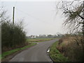
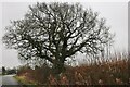
6
Mill Lane, near Meesden
Mill Lane is a minor road in north Hertfordshire countryside. Here the road bends sharply to the left.
Image: © Malc McDonald
Taken: 25 Jan 2020
0.11 miles
7
Lower Green to Lower Green
This bridle track begins a short way behind the camera at Mill Lane in Meesden Lower Green and ends near New Farm on the edge of Langley Lower Green. The line of trees in the middle distance marks the county boundary, so this is a view into Essex. Image], taken later the same day, gives a hint of the other end, Roper's Lane.
Image: © John Sutton
Taken: 17 Jan 2023
0.14 miles
8
Mill Lane, near Meesden
Mill Lane is a minor road through north Hertfordshire countryside.
This image was taken on a dull January afternoon. Trees were bare for the winter season.
Image: © Malc McDonald
Taken: 25 Jan 2020
0.15 miles
10
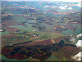
Former RAF Nuthampstead from the air
The RAF base closed in 1959. Click on this http://en.wikipedia.org/wiki/RAF_Nuthampstead to go to the wikipedia article about the base. Viewed from a Luton bound flight from Prague.
Image: © Thomas Nugent
Taken: 4 Nov 2011
0.23 miles